

This post contains affiliate links. If you buy something through these links, I may earn a small commission at no extra cost to you. I only recommend gear I’ve actually used out on the trails and really loved! Read my full disclaimer.
Tucked away in the Northwest of the South Island in Kahurangi National Park, the Heaphy Track involves a cumbersome car shuffle, flights or lengthy bus trips to get there and back again.
Winding its way from windswept beaches and nīkau palms across open tussock downs and through beech forest, the Heaphy nevertheless sits at the bottom of our NZ Great Walks list so far. The breathtaking beauty of our other New Zealand hikes is simply hard to beat.
This is the fourth Great Walk and the fifth multi-day track we’ve hiked in New Zealand (following the Routeburn Track, the Abel Tasman Coast Track, the Milford Track and the Queen Charlotte Track in the Marlborough Sounds region). We’ve enjoyed all these tracks enormously, so much so that the Milford and Routeburn remain in the Top 3 of our all-time favourite hikes.
Apart from being not quite as spectacular as some other walks, the Heaphy Track is also one of the more difficult (= expensive) Great Walks to organise. On the flip side, it’s a cheaper hike in terms of hut fees (being about half the cost of the Routeburn huts).

This is a long post, a cup of tea might help. 🙂
HIKING THE HEAPHY TRACK: WHAT TO KNOW BEFORE YOU GO
The Heaphy Track At A Glance


The Heaphy Track takes you from the West Coast across the northern tip of the South Island to Golden Bay in the Northeast. Since you’re in a remote corner of New Zealand—or as close to remote as it gets—the scenery does feel remarkably unspoilt and with far fewer traces of civilisation than on some of the other Great Walks.
At 78km, it is the longest of the 11 Great Walks, and hikers tend to take anywhere between 3 to 5 days, with 4 days being the most popular option.
TRACK ROUTE: WHICH DIRECTION SHOULD YOU HIKE?
You can hike the Heaphy Track in either direction, though Golden Bay to the West Coast (east to west) seems slightly more popular. We hiked it west to east for a number of reasons (more below).
Starting at Kōhaihai Shelter (West Coast) right on the beach, the track winds around beach cove after beach cove to the Heaphy River mouth. You’ll then follow the river for a few kilometres before winding your way through beech forest into the high country. From there, the track takes you through forest, low shrubs, creeks and rivers and across open tussock-covered valleys before descending down the range and ending at the Brown Hut trailhead.

There are five huts (six if you include Brown Hut at the Golden Bay end) along the Heaphy Track but almost no one will stay in all of them (unless you wanted a really leisurely hike). The main huts that most people will book are Perry Saddle, James Mackay and Heaphy Hut.
Instead of staying in the huts, you could also camp. There are campsites at all the huts and some in-between; with some of the facilities being more inspiring than others (e.g. the camping facilities at James Mackay include a kitchen shelter and tent platforms).
CHOOSING YOUR ITINERARY: 3, 4 OR 5 DAYS?
Most people hike the Heaphy Track in three or four days, depending on fitness, age and time constraints. We took five days as I’m fairly health-challenged these days and just need shorter days in order to be able to complete a hike (and I still had a massive flare-up afterwards).

Here are common hiking options:
- 3 days: Long days, bypassing most huts. Start at the Golden Bay end and stay at Perry Saddle Hut and James Mackay Hut.
- 4 days: More time and slightly shorter distances. Start at the Golden Bay end and stay at Perry Saddle Hut, James Mackay Hut and Heaphy Hut. From the West Coast, stay at Heaphy Hut, James Mackay and Perry Saddle Hut. If Perry Saddle is booked out, you could also stay at Gouland Downs Hut but this makes for a very long final day; note that there are also no cooking facilities at Gouland Downs.
- 5 days: Bookended by bigger days but two relaxing days in the middle with plenty of downtime. Start at either end and stay at Perry Saddle, Saxon Hut, James Mackay Hut and Heaphy Hut—reverse for starting at the West Coast end.
Transport-wise, you’ll need a car shuffle, vehicle relocation, bus transfer or flight to make this hike possible unless, of course, you want to hike back the same way you came. While the hike is 78km across the mountains, the road distance between the two trailheads is significantly longer and will take 7-8 hours of driving along slow, windy roads.
ELEVATION PROFILE
In terms of elevation, the Heaphy Track takes you from sea level over a mountain range back to (almost) sea level or vice versa.
You can either have a tough Day 1 if starting from the Golden Bay end (Brown Hut) or an uphill hike on Day 2 if starting from Kōhaihai Shelter on the West Coast.
From the West Coast, the track looks fairly flat for Day 1 but it’s actually a lot more undulating than I’d expected. It rarely felt like we were hiking at sea level but instead went up and down, weaving around coves and bends.
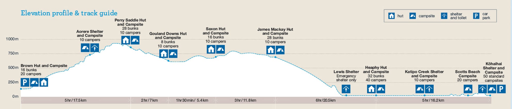
Once you’ve climb up the mountain range. between James Mackay and Perry Saddle, the track becomes undulating, snaking through the forests and across open downs. At Perry Saddle Hut, you’ve reached the highest elevation point on the track (880m), provided you’re not taking a side trip to the lookout at Flanagans Corner (915m).
Unless you’re ultrafit, everyone seems to be puffing up the long climbs, no matter if you’re going east or west. These sections are not difficult per se, they’re just really long stretches of incessant uphill.

I needed my trusty hiking poles for both climbing to James Mackay Hut on Day 2 and, surprisingly, for descending past Perry Saddle Hut on Day 5—my knees were not great on this hike and I needed all the help I could get.
For us, I think we made the right choice to hike west to east—this gave us a less strenuous day to start with, and allowed us to ease into the hike. It also meant that our packs were one meal lighter for the uphill section the next day.
BEST TIME TO HIKE THE HEAPHY TRACK
Like the Abel Tasman Coast Track, the Heaphy Track is open year-round with spring to autumn (October to April) being the most popular months for hiking.
Unlike sub-alpine tracks like the Routeburn, the Heaphy is safe to trek over the winter months though the weather is less likely to be amenable. Rain—and severe flooding—can occur at any time of the year but winter rains and cold temperatures make the summer months much more appealing.

We hiked the track in early April and only experienced some rain and inclement weather on Day 4 and the morning of Day 5 (when we were hoping for views, of course). The other days were dry, partly cloudy if not sunny at times.
Since the Heaphy is a shared track, keep in mind that from May to November, you will share the track with mountain bike riders. From what I’ve heard they can get up to some raucous partying in the huts at night. Obviously hiking the track is more exhausting than riding it!
HEAPHY TRACK PRACTICALITIES
Here are a few things to keep in mind when planning your Heaphy hike:
GETTING A PERMIT
Getting a permit for the Heaphy is nowhere near as difficult as for the Milford, the Routeburn or the Kepler Track. These three tend to book out within minutes while the Heaphy can often be booked a couple of months in advance or even less, making it a great alternative if the other tracks are booked out.
Check the dates for when the DOC booking system opens; this usually happens some time in May each year.
Some practical tips for booking:
- Be flexible: If you’re able to be flexible, you can generally find some dates where you can book the main huts for the Heaphy. Otherwise, keep checking the DOC booking system; people cancel all the time and you might be able to book last minute.
- Consider camping: It’s even easier to get a campsite on the Heaphy and it’s also cheaper (camping fees for international hikers for the 26/27 season are NZ$28 per night).
Fees vary depending on the season and whether you’re considered residing in New Zealand or live overseas. For the 26/27 summer season, the huts for international hikers cost NZ$66 per night.
For more information, including the most current fees, check the DOC Heaphy website.
TRANSPORT: GETTING TO THE TRAILHEADS
As mentioned, the trickiest part of the Heaphy Track isn’t the walking—it’s getting to and from the trailheads. Being so far north and out of the way, travel takes a long time and services don’t run every day.
On the West Coast, the Kōhaihai Shelter trailhead is some 110km north of Westport (last proper town, almost 2 hours drive); on the Golden Bay end, the Brown Hut trailhead is about 150km north of Nelson (2.5 hours). In-between is over 450km of slow, windy roads.

We looked at various options and ended up getting our rental campervan relocated with Heaphy Track Help from Kōhaihai Shelter (west) to the Brown Hut trailhead in Golden Bay (east). Car relocation tends to be cheaper from the West Coast to Golden Bay than the other way around.
In terms of transport options, one direction isn’t necessarily easier to organise than the other, though if you’re choosing the bus transfer, start at the Golden Bay end. That way you’ll have the long bus ride at the end of your hike when you’re knackered anyway and not to begin with.
Bus transfers usually take you to/from Nelson but they also often pick up along the way at Motueka, Tākaka and Collingwood (Golden Bay end), or Westport (West Coast end).
HEAPHY TRANSPORT OPTIONS
Bus Transfers: Good option if you don’t have a vehicle, though schedules can take some coordinating given the remote trailheads. Services connect the track ends to Nelson, Motueka, Takaka or Westport.
• Cost: Approx. NZ$235 round trip
• Operators: The Heaphy Bus (scheduled departures) or Trek Express (charter service)
Air Transport: A handy alternative if you’re short on time and want to get straight to the start or end of the track via regional flights and connecting shuttles.
• Operators: Golden Bay Air
Car Relocation: Most flexible option. You drive your own vehicle to the start, and it’s waiting for you at the other end. We used Heaphy Track Help and had no problems at all.
• Cost: Approx. NZ$465–NZ$515 depending on direction (+ NZ$50 for larger vehicles)
• Operators: Heaphy Track Help
Note: Given the massive 450km road distance between Brown Hut and Kōhaihai, it’s really important to organise your transport logistics well ahead of time.
Services are very limited outside the spring-to-autumn season and a private car shuffle might be your best option then. Even in season, it can be hard to organise a bus transfer (the Heaphy Bus only runs twice a week) or a car relocation unless you organise it well in advance.
HUTS AND CAMPING
The five huts along the Heaphy are staffed or regularly visited by hut wardens/rangers. Unlike at the more popular Great Walks, none of the hut wardens along the Heaphy gave nightly talks but most of them were still keen to interact with hikers, say hello and share tips and weather insights for the next days.
The facilities in the huts on the Heaphy Track are just as fantastic as on other Great Walks, perhaps with the exception of the older but charming Saxon Hut and historic Gouland Downs Hut, which really is ‘quaint’ and rustic, and essentially an old mountain hut.


- Cooking facilities: Gas stoves provided in all huts (except Gouland Downs); bring your own cooking equipment + bowl/cutlery and obviously food.
- Cleaning liquid: Available in most huts. We generally bring our own cleaning cloths to avoid any food contamination and because sometimes they’re not quite as clean as I’d like them to be.
- Toilet access: Either flush or drop; cold water sinks.
- Filtered water: Available at each hut.
- Sleeping mats: Provided in all huts. All of the huts have the newer thick blue ones.
- Solar-powered lighting & fireplaces: The new huts all have lighting, heaters (fireplace) and drying racks. Saxon Hut only had a small wood heater but the hut is small and warmed up easily.
TOILET ACCESS
While there aren’t as many toilets along the Heaphy as on other tracks, every hut and every shelter has them so you’re generally not too far from one.
Every single toilet was clean with plenty of toilet paper, though some were slightly more sandfly-infested than others, which always makes pulling your pants down so much fun.

Bring a Kula Cloth if you’re a lady hiker and no actual toilet is in sight.
OUR TRIP LOGISTICS (AND WHAT WE SPENT)
Since we flew to New Zealand specifically for the Heaphy Track, we decided that a campervan rental was the easiest option to deal with the transport logistics.
Arriving in Christchurch three days before our hike, we had enough time to pick up the van, do our grocery shopping and drive the roughly 450km to the West Coast trailhead. Afterwards, we spent another four days exploring Golden Bay and Nelson Lakes before flying back to Australia.
We decided to stay at Karamea Memorial Domain Camping Ground, about 17km south of Kōhaihai, so we could have one last shower before the hike. It turned out far nicer than expected, and we ended the day with a lovely sunset over the ocean.
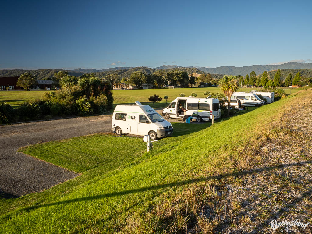
At the Golden Bay end, I had booked us into Collingwood Holiday Park for a night (about 32km away), which we then extended since we enjoyed the relaxed setting and beautiful scenery so much—in fact, it’s now on my list of best campsites on the South Island.
Here’s how we organised our Heaphy Track hike:
- Duration: 5 days, Kōhaihai Shelter to Brown Hut (west to east)
- Huts: Heaphy Hut, James Mackay Hut, Saxon Hut and Perry Saddle Hut
- Transport: Used Heaphy Track Help to relocate our campervan. Dropped it off at Kōhaihai Shelter on Day 1, and picked it up at Brown Hut car park on Day 5
ESTIMATED COSTS
Given its remote location, the Heaphy Track is straightaway more expensive unless you’re already in the area.
If you have your own vehicle, your biggest cost is going to be the car relocation (min. NZ$465) or the bus transfer (min. NZ$265 per person). You can only avoid that cost by hitching a ride, not going all the way to Nelson, or hiking back to your starting point.
Camping will make the actual trail cost cheaper but staying in the huts is really not that much more (compared to other Great Walks). As an international (i.e. non-Kiwi) hiker, the cost will be NZ$28 a night (vs. NZ$66 for a hut bed) during the main season.
We spent:
- Heaphy DOC hut permits: NZ$66 pp/pn (international) → NZ$528 total
- Campervan relocation: NZ$455 + NZ$50 (additional campervan fee)
- Total: NZ$1,033 (~AU$840) (2 people)
Added to that would be the five days of rental costs for the campervan hire while we were hiking, and any food we bought pre-hike.
USEFUL GEAR TO PACK FOR THE HEAPHY TRACK
Given the annual rainfall is not insignificant, rain gear is essential for the Heaphy. Here are a few other things that were useful on our hike:
HEAPHY TRACK GEAR GUIDE
5-DAY HEAPHY TRACK ITINERARY & TRIP REPORT
Like on most of our New Zealand trips, we went on our Heaphy hike in early April.
We were fairly lucky with the weather; it was just right for hiking—mostly blue skies to partly cloudy conditions over the five days. Only on Day 4 and the morning of Day 5 did we have overcast skies and a steady drizzle, which unfortunately meant limited views around Perry Saddle.

If you’re planning to hike east to west (Golden Bay to West Coast), just reverse everything, knowing you’ll start with a steep climb on Day 1.
DAY 1: KŌHAIHAI – HEAPHY HUT | 16.2KM
I woke with my familiar Day 1 anxiety, and was thus keen to get going early. Once we arrived at Kōhaihai, I realised we’d made the right decision to not stay here—the entire camping area was swarming with pesky sandflies that would have driven us mad while packing for the hike. (Vicious sandflies aside, it is a gorgeous spot.)
After dropping the keys for the van off at the pre-arranged spot in the car park, we were on our way just after 8am. Although it was somewhat cloudy with a light drizzle, the ocean was flat as a pancake and not a ripple was to be seen in the Kōhaihai River—quite the serene start.

We had purposely chosen to hike west to east to avoid a drawn-out uphill battle straight out the gate. That said, even the Kōhaihai to Heaphy Hut stretch is not entirely flat—you’re greeted by a 100m climb up to Kōhaihai Bluff right away, followed by a few rolling, undulating kilometres.
After the first climb, the track crosses the river via a suspension bridge (New Zealand really knows how to build these), and then more or less hugs the coastline as it weaves in and out of tropical forest sections.

Along the way you’ll cross a few more suspension bridges and catch intermittent views of picturesque nīkau palms, sweeping, sandy beaches and lush coves.

Past Scotts Beach, about 5km in, the track soon levels out and it is then reasonably fast walking.
To be honest, this stretch is probably the most scenic of the entire track, and it does make for a perfect way to finish the hike, not start it like us. The only problem with fully enjoying it is that you can barely stop: You instantly become a sandfly magnet. ‘Highly annoying’ would be an understatement.

Unfortunately, my old ITB niggle soon turned up the volume, and though I tried hard to ignore it and couldn’t quite believe it had made a reappearance after so many years playing along nicely, it increasingly got hard to dismiss. By mid-morning I was in serious pain and no amount of stretching helped.
We decided to stop for lunch and rest at Katipo Creek Shelter but gave up that idea as soon as we arrived. The shelter was infested with sandflies, you could literally see the black swarms zooming around. I hurried to the toilet followed by a quick lunch on the go as stopping was impossible.

By early afternoon, we reached Heaphy Hut. Once I’d limped into the bunk room to unpack, I realised that I’d completely forgotten to bring any ibuprofen (that’s a first—my first-aid kit usually resembles a small ambulance) and I had to turn straight to heavy-duty drugs. Hm, not good.
HEAPHY HUT
Heaphy Hut is beautifully located in a clearing near the mouth of the Heaphy River.
With 32 bunk beds on offer, most hikers will stay here for their first or last night, and it does have a rather pretty outlook. There are four separate bunk rooms, a large common room and a lovely wrap-around verandah that nobody can use since the sandflies have commandeered it.


After some rest and a well-earned cup of tea, we went for a wander around the river mouth.
As long as you kept moving, the mean little insects left you alone but stop to take a photo and you got pestered beyond what’s humanly possible to bear. I generally have a higher tolerance for these peskies than the husband but even I could only handle the swarms for so long… I pity anyone who decides to camp here.
CAMPING OPTIONS
You have three camping areas between Kōhaihai and Heaphy Hut:
- Scotts Beach: A grassy, shady area with a picnic table or two; alternatively, camp on the beach if there’s no wild weather and you don’t mind sand in your tent
- Katipo Creek Shelter: Overgrown and infested with sandflies; not recommended
- Heaphy: Large grassy but somewhat slopey area with great views of the river mouth while being surrounded by enthusiastic sandflies


DAY 2: HEAPHY HUT – JAMES MACKAY HUT | 20.5KM
We woke up to clear blue skies, and although today was a big day, we didn’t leave quite as early as hoped. My knee didn’t feel amazing but I’d taken some serious drugs and was determined to complete the hike. Today was the day I was most nervous about as uphill isn’t my strong suit.
By 8:30am we were well and truly on our way, and initially made good progress.
From Heaphy Hut, the track is very flat as it follows the banks of the Heaphy River. A mere 45 minutes later, we reached the new bridge across the Heaphy River—at a whopping 149m long, it’s the longest suspension bridge DOC has ever installed. And indeed it’s impressive.

Not long after crossing the Heaphy River, you’ll reach the Lewis River suspension bridge (101m) before arriving at Lewis Shelter, another new and impressive structure.
The old hut was destroyed some years ago, and DOC decided not to rebuild it as a hut but turn it into an emergency shelter instead. The shelter is fully enclosed and would offer great protection in inclement weather.


It’s perfect for a break and being further away from the coast, the sandflies are much less annoying here (still there but bearable), so we could actually sit on the verandah and enjoy morning tea before tackling the hardest part of the day.
If you’re keen to explore the old hut site on the riverbank, there’s a sidetrack further along before the trail begins ascending. We gave it a miss as we had the big, long climb ahead of us and time was getting on. I’m told by rangers that there isn’t much to see now, only a couple of old wooden logs.
Past the shelter, the track winds steadily up and up through beech forest until you reach James Mackay Hut. It is not outrageously steep or overly difficult, it is just a long 12km stretch up the mountain range with little, other than the impressive birdlife, to distract you from your puffing.

The only thing that might keep you entertained is looking for the tiny sky-blue mushrooms (werewere-kōkako). They’re bright blue but absolutely tiny, maybe as big as half your index finger, and we found about four or five growing along the side of the track.

After huffing and puffing for a solid 3.5 hours, we reached James Mackay Hut by mid-afternoon.
JAMES MACKAY HUT
At 700m above sea level, James Mackay Hut offers far-ranging views towards the Heaphy River mouth and the wild West Coast.
Built in 2014, the 28-bed hut is relatively new and so offers separate bunk rooms like Heaphy Hut (between 8 to 12 bunks each and cubby holes for your gear), a large common room, and a verandah that you can actually use (still with sandflies but bearable).


The common room has large windows and makes the most of the view towards the Tasman Sea so you can still enjoy the scenery laid out before you without having to deal with sandflies.

CAMPING OPTION
After the Heaphy camping area, your next spot for camping is at James Mackay Hut. The camping area is to the left of the hut and pretty nice with wooden platforms and an almost completely enclosed kitchen shelter.


SIDE TRIPS: MOUNT OTEPO & CREEK BATH
If you need more exercise, or aren’t as decrepit as I am these days, you could head up a rough track to the trig point at Mount Otepo for more sweeping views over the mountains. Alternatively, jump into the creek for a bath near James Mackay Hut. Mud maps for both are in the common room at the hut.
Given my sore knee and general tiredness after today’s walk, I was just thrilled to have made it up the hill, and focused on resting my knee and working my way through my mountain of gluten-free snacks.
DAY 3: JAMES MACKAY HUT – SAXON HUT | 11.8KM
Today was a much shorter day and since there was only minimal elevation involved, I felt much happier already. After getting sidetracked by the antics of a cheeky juvenile kea for a while and chatting to a camper, we left around 8:30am again.

This stretch is the easiest (bar some of the flat sections on Day 1) as the track starts winding its way across Gouland Downs. It’s quite a pretty section, varying from tussock flats to beech forest, low shrubs and small streams criss-crossing the landscape.

There are intermittent views across the downs and mountains ranges but you also often find yourself hemmed in by low shrubs or forested sections.
The wetland sections generally have boardwalks, which always make hiking so much quicker (and more fun, I love a good boardwalk 🙂 ). That said, we dawdled and took our time, and only arrived at Saxon Hut by lunchtime.

SAXON HUT
Named after James Saxon, a 19th-century surveyor, Saxon Hut is an older mountain hut with an open-plan design: Bunk platforms at one end, and tables and benches at the other. It’s a small hut comparatively, with space for 16 hikers—though if it was full, it would be rather tight.


The hut has some nice decking around it where you can sit in the sun provided the winds across the valley aren’t so icy that you’ll soon run inside. I found a spot at the back of the hut out of the wind and spent a good part of the afternoon relaxing and reading.
We thought we might be on our own this night until we were joined by a guided group of five hikers and two guides in the early evening. The guides took up the whole kitchen space, cooking an insanely elaborate meal (salmon, broccolini, fresh salad, … and a mountain of pancakes for breakfast) but sadly, didn’t share any of their spoils with us. Luckily it was a family so they weren’t particularly rowdy and went to bed at a reasonable hour—always a bit trickier when you’re in an open hut.
CAMPING OPTION
The camping area is just behind Saxon Hut and like at James Mackay features wooden platforms from where you have a lovely outlook across the valley and tussocks flat. There are a couple of picnic tables and covered sinks here but no dedicated kitchen shelter.


SIDE TRIP: SAXON RIVER
Behind Saxon Hut runs a shallow, little creek that has one spot just deep enough for a little bath if you fancy a rather refreshing swim. Even if you don’t feel like jumping in—can’t blame you, I didn’t—it’s a nice little wander that will take about five minutes.

DAY 4: SAXON HUT – PERRY SADDLE HUT | 12.4KM
The next morning we woke up to grey skies with the distinct promise of rain. We left at our usual time around 8:30am, even though we actually tried hard to be on our way earlier. I was starting to feel quite tired and couldn’t get moving.
The track initially heads through the open downs and it’s reasonably fast walking past the tussock-covered flats and creeks dissecting the downs. By the time we reached the Big River, a light drizzle was starting to set in and any photo stops were rapidly coming to an end.

Field Notes: Wet Weather Gear
The Heaphy can experience sudden weather shifts, and on Day 4 the drizzle soon turned into light but steady rain. I wore my Patagonia TorrentShell 3L rain jacket along with my matching Patagonia TorrentShell rain pants, and they kept me completely dry without feeling like a plastic bag. They’re tough, I can shove them in and out of my pack all day, and they have kept me dry on the trails so far.
Check out the Patagonia TorrentShell 3L Jacket →
You can see the rest of the gear I use to stay dry and happy on my full gear list.
We’d thought about exploring some of the old limestone caves and arches along this stretch but with the weather getting worse, we ditched that idea and headed onwards into the more forested parts.
Before reaching Gouland Downs Hut, the beech forest has a fairytale-like feel, and indeed is called the ‘Enchanted Forest’ here. Once you reach it, you know you’re not far from the hut now.

Gouland Downs is a historic hut (640m), and it’s delightfully cosy. While there is a fireplace, there’s no gas cooker so remember to bring your own stove and gas, or plan a cold meal.
We stopped for morning tea and to put our rain jackets and pants on as the drizzle was starting to turn into steady rain.
Past the hut, the track leads gradually uphill as you’ll leave the open country of Gouland Downs and head towards Perry Saddle. Provided there’s no rain or mist, you’ll get sweeping views across the tussocky rolling ranges.

Along the way you’ll pass Boot Pole where people have hung up their boots—who exactly? do people bring spare boots to hang them here??—and Picnic Table Corner, which, as far as I could tell, had one picnic table on offer.
The track soon enters beech forest again and after what felt like hours, we finally reached Perry Saddle Hut just around noon. Since we had a fairly short day, we were the first to arrive and then spent a good hour talking to the ranger.
PERRY SADDLE HUT
Built in 2012, Perry Saddle Hut (870m) is tucked into the crest of the saddle and just as comfy as the other huts on the Heaphy Track. It has a distinct alpine feel given its mountain surroundings.

Like the other new huts, it has a large common room, four individual bunk rooms (28 beds in total), and a wrap-around verandah with valley views.


The one real negative about Perry Saddle is the toilet situation. The huts on the Great Walks usually feature flush or drop toilets a short walk away, frequently connected to the hut itself, especially for the newer ones. Oftentimes the access to the toilets is covered but even when it isn’t, you can generally get there without stepping into deep puddles of mud.
Not so at Perry Saddle. The (drop) toilets are a ridiculously long way away and when it rains, you cannot avoid slipping in mud as you make your way up a little incline to reach them. Total pain, especially in the dark.
CAMPING OPTIONS
On this stretch, you’ve got the choice of camping at Gouland Downs or further along at Perry Saddle.
- Gouland Downs: A couple of wooden platforms next to the historic hut surrounded by beech forest.
- Perry Saddle: Well-established, though it’s a little odd how the campsites surround the hut with a couple slightly further away, offering more privacy. Has a large, dedicated kitchen shelter that’s pretty impressive.
- Aorere Shelter: About 5km past Perry Saddle Hut, a grassy area with sinks and a shelter.


SIDE TRIPS: MOUNT PERRY & MOUNTAIN SPA
If you haven’t had enough exercise for the day, you can head to the summit of Mount Perry (1,238m). We hiked up the unmarked route partway but turned around as it was just too muddy and slippery, and my knees weren’t that keen. Given the misty weather, the reward was also going to be questionable.
The other little side trip you could take is just behind Perry Saddle Hut to the “Mountain Spa“, i.e. Gorge Creek has a waterhole just deep enough to sit in. It’s a rooty and, after rain, muddy scramble down to the creek, and while quite pretty, I wasn’t feeling a swim in the cool conditions.

A few other hikers went down for a swim, and it’s probably just the ticket if you walked uphill from Brown Hut on a hot, sunny day.
DAY 5: PERRY SADDLE HUT – BROWN HUT CAR PARK | 17.5KM
Our last morning greeted us with drizzle and such low clouds that any valley views were completely obscured. We donned our rain gear and were on our way just after 8am.
My knees and legs were not happy at all anymore, and I could feel the effects of the strong anti-inflammatory meds on my body—my mast cells were not reacting kindly. All I could think about was getting off the track and resting my body.

Initially the track climbs again until you reach Flanagans Corner, the highest point on the Heaphy Track (915m), about 1.5km past Perry Saddle Hut. It’s only a short detour but we gave it a miss due to the weather and my increasing inability to walk properly.
From the Flanagans Corner turnoff, the track descends steadily, sometimes more steeply than at other times. Along the way, you cross a few small streams coming off the mountains and get some fairly epic valley views if the weather plays nice.

When we reached Aorere Shelter (800m), about an hour after we left the hut, the rain had more or less stopped, and we could divest ourselves of our rain pants. In fact, as the day wore on, the weather got increasingly sunnier and warmer.

By the time we reached the Brown River and nearing the end of the downhill hike, we were positively hot and sweaty, and I couldn’t wait to take my boots off.

After taking our obligatory end-of-hike photo at the trail sign while madly swatting sandflies away, we couldn’t wait to get to our campervan.

The van was exactly where it was meant to be in the Brown Hut car park, and by 1pm I was very relieved to be rid of my heavy pack, take the boots off my incredibly sore and exhausted feet, and rest up.
I had blisters on my heels, an extremely sore and swollen left big toe, a sore right ankle bone, not to mention swollen knees, ankles and feet. I could barely walk. A month later, I lost my left big toenail. (And this was only half of my flare-up symptoms. Unfortunately, my body took a bit of a beating on this hike.)
KEEN TO HIKE THE HEAPHY TRACK?
The Heaphy Track isn’t spectacular in the same way the Milford Track or the Routeburn are but it is a peaceful hike through a relatively unspoilt and remote part of New Zealand wilderness. The birdlife here is terrific, especially when you hike through beech forest and find yourself immersed in bird chatter.
Day 1 along the wild West Coast is the most scenic day but it’s also the most sandfly-infested walking you’ll ever experience. I really enjoyed walking around the tussock flats from James Mackay to Perry Saddle Hut, and with clear weather, this would be a really lovely section.
Would we do it again? Probably not, or least we’re not in a hurry to do so. But it’s still worth it if you want peace and quiet while hiking and don’t expect superlatives around every corner.
Happy hiking,

Planning more multi-day hikes? Around the corner in Golden Bay is another Great Walk, the Abel Tasman Coast Track. Slightly further in the Marlborough Sound region is the Queen Charlotte Track, another beautiful 4 or 5-day walk in the north of the South Island.


No Comments