
I’ve long had East Arnhem Land on my radar but it’s not exactly easy to get to.
By road, it’s roughly 600km along a dirt road, which makes it just a tad harder to reach than many other places in the Northern Territory, not to mention the permit situation.
We finally managed to get there on our 8-months road trip last year. We ended up spending about 10 days around the top end of the Gove Peninsula, and while we have no regrets, it turned out to be one of those places where visiting once is enough.

WHY VISIT EAST ARNHEM LAND?
East Arnhem Land is a vast geographical area extending roughly south from Kakadu National Park to the Gulf of Carpentaria in the east.
It is Aboriginal-owned land, with the mining town of Nhulunbuy (Gove) servicing the nearby bauxite mine and operating on a lease agreement for a few more years. The region is home to the Yolŋu People, many of whom live in small communities on traditional homelands scattered across East Arnhem. It’s a place rich in history, culture and arts but it’s also remote, rugged and a genuine 4WD adventure.
For us, the trip was part remote adventure, part cultural experience and part scenery. If you’re into fishing (we are not), you’ll probably love East Arnhem.
PLANNING YOUR EAST ARNHEM LAND ADVENTURE
EAST ARNHEM LAND ROAD TRIP AT A GLANCE
Travelling to East Arnhem Land presents a serious adventure—corrugated roads, travel permits, lack of mobile coverage and limited supplies until you reach the end. It’s actually not as difficult to organise as it might seem at the outset but weather conditions can make the whole journey highly unpredictable.
We originally planned to head into East Arnhem in late May but had to postpone our plans until mid-June as the road was still closed from a late wet season. The later in the dry season you plan your trip, the higher the chance the track will actually be open.
BEST TIME TO VISIT EAST ARNHEM LAND
The dry season months, roughly May to September, are the only realistic timeframe for the trip. Temperatures are quite pleasant—expect high 20°Cs to low 30°Cs during the day with low 20°Cs overnight and relatively little humidity.
Because the travel window is short, camping permits are highly sought after, especially for the July school holidays (keep in mind that the NT usually has a three-week winter school break).
HOW MUCH TIME TO PLAN
You will need four days for the transit alone—two days in, two days out—and from there, it depends how much you want to see and do. We met people who were spending just two days exploring while others stayed for six weeks (understandable if you’re into fishing).

We planned about seven days alongside our four driving days. If you only wanted to see the main sights and relax a bit, a week in the region is more than sufficient.
DRIVING THE CENTRAL ARNHEM ROAD: CORRUGATIONS AND CONDITIONS
The wet season is different every year, and so are the resulting road conditions for Central Arnhem Road.
It’s roughly 675km from the Stuart Highway turnoff to Nhulunbuy at the tip of the Gove Peninsula. While that’s a long way, the first 100km are now sealed, leaving “only” just under 600km for the dirt road adventure.
| Route Leg / Destination | Distance | Road Type & Conditions | Vehicle Suitability |
|---|---|---|---|
| The Central Arnhem Road Gateway (Sealed) | |||
| Stuart Hwy Turnoff to Barunga/Beswick | ~100 km | Fully sealed highway | Standard 2WD / All caravans accessible |
| The Long Dirt Track (Unsealed & Remote) | |||
| Beswick to Mainoru Outstation Store | ~100 km | Unsealed gravel, expect corrugated stretches | High-clearance 4WD / Off-road vans only |
| Mainoru to Nhulunbuy (Gove) | ~475 km | Expect rocky sections, corrugations, bulldust patches, river/creek crossings & concrete floodways | High-clearance 4WD (snorkel highly recommended) / Off-road vans only |
| Dhimurru Recreation Area Tracks (Gove Peninsula) | |||
| Campground Access Tracks (Stops 1–6) | Varies | Narrow bush tracks, washouts, deep sand, tight corners and creek crossings | Strictly high-clearance 4WD. Off-road camper trailers only. Caravans not permitted. |
Much of the drive is through savannah woodlands, which gets more tropical and monsoonal rainforest-y as you head east.
We encountered everything from recently graded, smooth dirt to deep corrugations, sharp rocky sections, seriously long water crossings, bulldust and potholes the size of minor meteorites. Our driving speed varied from crawling at 30km/h to smooth sailing at 80km/h.
We’re reasonably cautious drivers—we definitely wanted to avoid a breakdown out here or collide with feral donkeys or water buffaloes.

The road is graded in sections but it’s so long that you’ll invariably hit a mix of good and bad patches. On our trip, the surface got progressively worse the further east we travelled, bar a few random sections that had been freshly graded.
To know exactly what the road conditions are in a given year, your best resources are:
- Road Report NT: Check to see if the road is open and which sections are currently dicey.
- Central Arnhem Road Facebook group: Join the group for the most reliable, up-to-date reports on road updates and current conditions.
PERMITS AND CULTURAL CLOSURES
If you’re travelling the Central Arnhem Road all the way to the Gove Peninsula/Nhulunbuy, you need two distinct permits. If you plan on camping within the Dhimurru Recreation Area—instead of camping in Nhulunbuy—you will also need to secure individual campsite bookings.
- Northern Land Council (NLC): Transit Permit to travel the Central Arnhem Road (free)
- Dhimurru Aboriginal Corporation: Dhimurru On Country Pass ($80 pp) + Recreation Area campsite permits (= bookings)
You’ll need to organise everything well in advance as some of the campsites are very popular and book out months ahead.
Dhimurru’s updated website makes it much easier to find permit information and check campsite availability. Because each system relies on the other, you need to apply for your permits in this order:
- Apply for the Dhimurru On Country Pass first. You’ll need your pass number for your campsite bookings in the Dhimurru Recreation Area.
- Secure your town accommodation or caravan park bookings if you’re staying in Nhulunbuy, or organise your Dhimurru campsite bookings using your pass number.
- Apply for your NLC transit permit last. The Northern Land Council requires confirmation of your camping / accommodation bookings as evidence before they’ll issue the transit permit.
If you want to visit other Indigenous homelands, such as Bawaka, you’ll need separate permissions. Access is usually granted via your camping / accommodation booking but you must ensure those dates are included on your NLC application.
CULTURAL CLOSURES
The one thing I didn’t bank on was temporary closures for cultural reasons.

In our case, I’d managed to snatch up a booking for one night at Cape Arnhem—one of the most popular camping spots—only to find out upon arrival that the entire area was closed following the passing of an influential elder a few weeks earlier. For the same reason, several town beaches and community sites were off-limits during our trip. So, we had to adapt our plans and move on.
ESSENTIAL SUPPLIES & 4WD PREPARATION
In terms of supplies and fuel, it’s pretty simple:
- Katherine: Get your main supplies and fuel up before you head off.
- Mainoru Outstation Store: Stop here to top up with fuel and grab a pub-style meal. Though not quite at the halfway mark, most people break their journey here and camp for the night.
- Nhulunbuy: Full supplies, fuel and gas bottle refills available.
Nhulunbuy (Gove) has a small Woolies, a regional hospital, a nice little bakery, a café, hardware shop (gas refills), fuel stations, a mechanic and even a regional airport. Grocery prices are actually quite reasonable here and you’ll find all the standard staples, including a few gluten-free options (I’m always over-prepared as you never know what may or may not be available).

Your 4WD needs to be set up for long stretches of corrugations and be in pretty good nick before you head off. We wouldn’t have attempted this road without a snorkel—more critical if you go earlier in the dry season than perhaps towards the end. Have solid tyres and carry at least one spare.
Need to sort out your satellite comms? I’ve written a detailed Starlink vs Zoleo vs PLB remote comms review if you are trying to work out your own satellite setup for the trip. Nothing overly complicated, we like things to be simple.
It’s also a good idea to carry essential spare parts as well as emergency communications. We met more than one person who was stuck in Gove waiting for their car to get repaired or just waiting for parts—usually with lengthy wait times attached.
We hit one particularly dreadful pothole at high speed just after one of the Goyder River bridges but miraculously didn’t sustain any lasting damage. Our Prado really should have broken right there and then but didn’t (instead, it saved the breaking part for the Kimberley later in the trip 😆).
East Arnhem Land Gear Essentials
10-DAY ROAD TRIP INTO EAST ARNHEM
Out of our eight months on the road last year, there were really only two times when it felt like a real, full-blown adventure: Heading up to Kalumburu in the North Kimberley, and trekking out to East Arnhem Land.
It’s not that you don’t see other travellers along Central Arnhem Road—far from it. It’s the state of the road that makes it an adventure.
JURASSIC PARK LOOKOUT | ~120KM
After about 120km along Central Arnhem Road, you’ll come past a large pullout area on the left side of the road. It’s worth stopping here.

Commonly referred to as Jurassic Park Lookout, you can easily see why as it got its name. From here, you’ll have expansive, sweeping views over the ancient plains and plateau ranges.
MAINORU OUTSTATION STORE: HALFWAY POINT | ~200KM
Driving the Central Arnhem Road is time-consuming and exhausting because you have to concentrate on the road conditions every single second. We’d always planned to break our trip up and do it over two days.

Mainoru Outstation Store is only 200km into the journey when coming from the Stuart Highway but it’s the typical spot to stop for the night. You can’t legally just pull over and bush camp anywhere along the road (despite what WikiCamps might say) since you’re mostly travelling through private Indigenous Lands.
In any case, Mainoru is a literal oasis: From grassy campsites (both powered and unpowered), accommodation (if you need an actual bed), hot showers to a lush, tropical swimming hole in the Mainoru River. You can also top up your fuel, do some laundry and enjoy an outback dinner.

We stayed here on our way to Nhulunbuy and also on our return as we were exhausted from the corrugations and the general state of the road.
DHIMURRU CAMPS AND GOVE PENINSULA SIGHTS
We focused our East Arnhem Land road trip on the Dhimurru Recreation Area around Nhulunbuy, camping in several different spots.
I organised our campsites along a loose loop so we could avoid driving endlessly back and forth between campsites and sights across the peninsula that we wanted to visit. It didn’t entirely work as Cape Arnhem was closed, and we needed to pay a visit to the hospital in Nhulunbuy twice.
| Campsite Name | Environment | Toilets | Wind Cover | Top Site Pick |
|---|---|---|---|---|
| Manaŋaymi (Scout Camp) | Lush tropical bush | Yes | Good | Site #5 (more separate but a bit uneven) |
| Garanhan (Macassan Beach) | Red laterite cliffs | Yes | Very Exposed | Site #1 (level-ish + view) |
| Wathawuy (Latram River) | Inland river pools | Yes | Good | Any (bollard layout) |
| Baŋambarrŋa (Rainbow Cliff) | Clifftop ocean front | Yes | Moderate | Site #1 (our favourite) |
| Wathawuy (Goanna Lagoon) | Inland shallow pools | Yes | Good | Any (bollard layout) |
| Guwatjurumurru (Giddy River) | River gorge | Yes | Good | Any |
Some of the Dhimurru campsites are only accessible with a camping permit and are off-limits for day visitors; others are for campers and day visitors alike.

A Note on Caravans: The camping areas around the Dhimurru Recreation Area are not caravan-friendly—in fact, caravans are not permitted within this IPA (Indigenous Protected Area) at all. You can generally get an off-road camper trailer in though.
Your options with a caravan will be restricted to staying in town at Walkabout Lodge or further away at Manyimi Campground (next to the Gove Yacht Club), which usually requires a 5-night minimum stay.
STOP 1: MANAŊAYMI (SCOUT CAMP)
Manaŋaymi (Scout Camp) Camping Area At a Glance
Pros: Lush, tropical bush setting; toilet available (but dirty).
Cons: No privacy and likely very noisy if full; sites are right next to each other (except for #5).
Costs: $20 pp/pn (2026); Pre-bookings required via Dhimurru Aboriginal Corporation

Scout Camp is on the northern side of Central Arnhem Road and located in a lush, tropical bush setting along a creek.

There are five sites but we were both a bit disappointed when we got here as they’re set up right next to each other, almost in a sort of group setting. Fortunately, it was very quiet and we were the only campers but I wouldn’t want to camp here when all sites are booked.
In any case, Site #5 would probably be the pick of the bunch as it’s a bit separate from the others (though slightly more uneven as well).
The toilet here was also the worst—pretty full, smelly and dirty.

What was very nice about this site: It was a quiet, peaceful spot with no wind where we could have some downtime and relax for a couple of days after the exhausting drive out to East Arnhem.
From here, the plan was to camp at Cape Arnhem for a night but that got thrown out the window when we learned that the entire cape area was closed off for cultural reasons. We managed to book a second night at Scout Camp and stayed put.
STOP 2: EASTERN BEACHES — GARANHAN (MACASSAN BEACH)
Garanhan (Macassan Beach) Camping Area At a Glance
Pros: Sandy, beachfront camping along red rocks; Macassan Stone Pictures site; sites are mostly spaced out; non-smelly, clean toilet a short walk away.
Cons: Very windy with little protection for sites #3-5; mostly uneven ground.
Costs: $20 pp/pn (2026); Pre-bookings required via Dhimurru Aboriginal Corporation
Moving on from Scout Camp, I’d booked two nights at Macassan Beach, one of the eastern beaches, as we had planned to do the Dhimurru Coastal Walk.
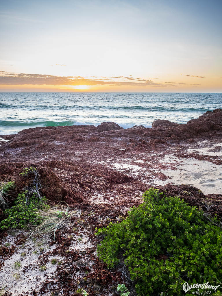
After the bush setting, Macassan Beach is a lovely coastal sight—the sharp red, laterite rock shelf set off against the blue ocean and the golden sandy beach. I would have loved this spot if it had been half as windy as it was! The tradewinds are really howling here.
The nice thing about Macassan Beach is that the sites are separated so you don’t get that sardine-feeling and can enjoy some space (with #3-5 being the furthest dispersed).

I’d booked Site #4, which turned out to be very uneven, sandy and tricky to set up with our rooftop tent. Since no one else was camping there that night, we decided to move to Site #1, which was not only a bit more level but also offered slightly more wind protection and had the prettiest views over the beach.
WURRWURRWUY: MACASSAN STONE PICTURES | 200M
The Macassan Stone Pictures are along a very short walk right at Macassan Beach.

The stone pictures document the visits of the Macassan people (now Sulawesi, Indonesia) to Yolŋu Country in the 18th and 19th century. The trade largely focused on sea cucumber (trepang), which the Macassans then sold on to China—globalism was already thriving. 😉 In the early 20th century, the South Australian government effectively put an end to the trade relationship when it started to collect customs duty aggressively.
Today you can take a short stroll around a few sites of stone arrangements—or ‘stone pictures’—alongside interpretative panels so you can work out what you’re actually looking at.
DHIMURRU COASTAL WALK: BINYDJARRŊA TO BARIŊURA | 7.2KM ONE-WAY
There aren’t a lot of formal hiking or walking tracks in East Arnhem Land so one thing we were really looking forward to was the Coastal Walk connecting the eastern beaches.
The track is meant to link Macassan Beach to the south with Binydjarrŋa (Daliwuy Bay) and to the north with Ŋumuy (Turtle Beach) and then Bariŋura (Little Bondi Beach). All up it’s supposed to be about 7km one-way.


After the husband was chased by an antsy, slowly charging water buffalo the night before, coupled with our general inability to find the overgrown track, we thought we might just go for a drive instead.
We tried once more from Turtle Beach but the track was just as overgrown here as it was at Macassan Beach—faced with the prospect of more water buffaloes and possibly other slithery critters, we decided to give up on the coastal walk.
TURTLE BEACH AND LITTLE BONDI BEACH
So instead of walking to Turtle Beach and Little Bondi Beach, we drove.
The camping area at Turtle Beach, while protected from the winds, is very, very small and very uninspiring. There are three sites nestled—or should I say ‘squished’—into the bush before you get to the beach. Unless you have a tent, you can’t camp on the beach here.

Turtle Beach has golden sand and is framed by the same red rock that is so stunning at Macassan Beach. Even though the ocean can be wild here, the beach is still quite pretty. Shame you can’t swim anywhere.
At Little Bondi, you can drive onto the beach and camp right there with direct ocean views. A much nicer spot for camping.

STOP 3: WATHAWUY (LATRAM RIVER)
Wathawuy (Latram River) Camping Area At a Glance
Pros: Lush, tropical bush setting; large sites, which are spaced out; clean toilet.
Cons: Actual sites behind bollards, need to camp in ‘parking area’ with RTT & camper trailers; nightly hooning.
Costs: $20 pp/pn (2026); Pre-bookings required via Dhimurru Aboriginal Corporation
From our windy spot at Macassan Beach, we moved on to one of the inland spots again, this time along the Latram River. We found this spot to be far nicer than Scout Camp, both in terms of the campsites (individual bays) and the actual river access.

The sites at Latram River are huge but they are fenced and have bollards at the entrance so you invariably end up camping outside your campsite if you have a rooftop tent or camper trailer. Out of the six sites, four other sites were meant to be booked but we were the only ones there yet again.

The only downside for this spot was the hooning that started at about 1:30am and kept me up for a couple of hours—not the most relaxing spot after all.
STOP 4: BAṈAMBARRŊA (RAINBOW CLIFF)
BAṈAMBARRŊA (Rainbow Cliff) Camping Area At a Glance
Pros: Large beachfront sites above the cliffs with great views; plenty of trees for shade and wind cover; toilet within easy walking distance; site #1 is completely separate.
Cons: Bollards in front of some sites so unable to drive onto sites; sites #2-4 are close-ish together.
Costs: $20 pp/pn (2026); Pre-bookings required via Dhimurru Aboriginal Corporation
After the wind at Macassan Beach and the hooning at Latram River, I was well and truly ready for a scenic yet serene camping spot—and I hit the jackpot with Rainbow Cliff.

There’s a reason why this spot is popular and all I could snatch up was a single night. We could’ve easily stayed a few nights. Only Site #1 was available, and we couldn’t have chosen a better site.
Sites #2-4 are much closer together and on the far side of the beach with the road sandwiched in-between, while Site #1 is directly on top of the cliffs, offering elevated views. But what’s even better is that it’s completely separate from the other spots—all sites were booked out but we couldn’t hear a single person. Total blessing.

The only thing I didn’t realise is that the camping area and the day-use area with the famous Rainbow Cliff are not in the same location. It takes a good 10-15 minutes to drive the 3km between the two areas along a fairly slow and bumpy track.
STOP 5: WATHAWUY (GOANNA LAGOON)
Wathawuy (Goanna Lagoon) Camping Area At a Glance
Pros: Beautiful, tropical bush setting with easy access to a sandy, shallow lagoon; individual, spaced out sites with tables; toilet within walking distance.
Cons: Can’t camp in the actual site with RTT or camper trailer; hooning until the early morning.
Costs: $20 pp/pn (2026); Pre-bookings required via Dhimurru Aboriginal Corporation
Goanna Lagoon is quite close to the Latram River campsites but it’s slightly further north. The freshwater creek here is even better as there are some beautiful shallow, sandy pools with crystal clear water.

This is a popular spot with the locals and seeing plenty of them splashing in the shallows, we decided that it must be clearly croc-safe and joined in—really more of a bathing experience given the limited depth. [Note: Don’t trust me—ask the locals first and jump in at your own risk.]

Like at Latram River, the sites are spaced out and we technically camped outside our campsite again. It’s a really lovely bush setting and I would have given it a rating of 3.5 tents if it wasn’t for the nightly hooning happening in this area too.
STOP 6: GUWATJURUMURRU (GIDDY RIVER)
GUWATJURUMURRU (Giddy River) Camping Area At a Glance
Pros: Bush setting perched along or above the Giddy River; sites completely separate; feels remote and isolated.
Cons: No swimming 🐊; nothing really wrong, just couldn’t settle.
Costs: $20 pp/pn (2026); Pre-bookings required via Dhimurru Aboriginal Corporation
After seven days camping across East Arnhem Land, we moved to our last spot at Giddy River, the furthest from Nhulunbuy for us—or in other words, we were now on our way back.

Giddy River has three very spaced out sites, you will be completely on your own here (bar any traffic that might go past). We camped in Site #2 high above the river at a slight bend where the Giddy River Waterfall topples into a deep, deep pool.
I found the whole area unsettling and just couldn’t relax—perhaps it was Arnhem Land fatigue, perhaps it was the sinister colour of the water, perhaps I was dreading more hooning that night. Who knows.
In any case, we decided to forego our second night here and head back out to Mainoru Outstation Store the next morning.

NHULUNBUY AND GOVE PENINSULA
Beyond the recreation area sites, we also spent a fair bit of time exploring Nhulunbuy, including the local bakery, the Refinery Café that had some gluten-free treats, and the local hospital, which turned out to be very adept at dealing with “tropical ear” (much to the husband’s ears’ delight).
The Gove Yacht Club is 15 minutes out of town and a popular spot for sunset drinks but the weather wasn’t playing along for us that afternoon so we headed off without the obligatory drink there.
BUKU-LARRNGGAY MULKA ARTS CENTRE (YIRRKALA)
The Yirrkala Art Centre, a short drive from Nhulunbuy, is quite literally world-famous—some of the local Yolŋu artists are represented as far as New York and their artworks are exhibited at renowed museums like the Tate Modern in London. The centre looks utterly unassuming from the outside but once inside, you’ll find this world of incredible art.
Apart from the natural sights, this visit was a real highlight for me. We probably spent a good two hours here, enjoying a bit of a tour with the lead curator, watching artists work, and learning about the different types of artworks and stories woven into the pieces.
Much of the art is traditional bark paintings and carved burial poles but there are also modern metal pieces, all of which I found fascinating. It’s very different from the Arrernte art and culture in Central Australia.
MISSED STOPS AND CULTURAL CLOSURES
Well, we also missed out on a few things.
Bawaka Homeland & Lonely Beach: I had hoped to visit Bawaka, about an hour south of Nhulunbuy, but the weather turned into gloomy rain for days and we couldn’t quite make it work with our dates so in the end we gave famous Lonely Beach a miss.
Gapuru (Memorial Park), Cape Arnhem (Wanuwuy) & The Northern Beaches: Despite snatching up a booking for Cape Arnhem, we didn’t end up seeing it as this area as well as the northern beaches outside Nhulunbuy (e.g. East Woody Beach) were closed for cultural reasons. Oh well.
IS EAST ARNHEM LAND WORTH THE DRIVE?
Heading out to East Arnhem Land is definitely one of the last real 4WD road trip adventures you can have in Australia. Amazingly, we didn’t break anything on this part of our Great Aussie Road Trip despite hitting a few potholes particularly hard.
We have no regrets about having done this 1,400km side trip; it’s great to have been to (a small part of) East Arnhem Land and learned more about Yolŋu culture and seen the vast landscape, not to mention the adventure that getting out there is. But would we ever go again? Probably not—it’s just not quite ‘our sort of place’.
Don’t let that put you off though—if you’re into fishing, sleep like a rock and thus won’t wake up to any hooning, and just love that sort of tropical bush or windy beach, then you’ll probably love it. 🙂
Happy exploring,

No Comments