
The Larapinta Trail is on Arrernte Country. I acknowledge the Traditional Custodians of this area and their connection to Country, and pay my respects to their Elders past and present.
Like the first leg from Redbank Gorge to Ormiston Gorge, we planned to hike the second stretch of our Larapinta Trail hike over three days. This leg though involved more kilometres, higher elevations, and bigger water carries.
Day 4-6 would cover Section 9 and 8, and take us from Ormiston Gorge to Serpentine Gorge, roughly 43km. It offers some of the best views on the Larapinta Trail.
We met a few hikers who were doing Section 9 in one day (29km!). I wouldn’t really recommend it unless you’re very fit, start well before dawn, and are prepared for a really big and exhausting day.

DAY 4: ORMISTON GORGE TO HERMIT’S HIDEAWAY (10.5KM) | SECTION 9
Day 4 started off very fresh with us waking up to a freezing cold morning at 4:30am.
It was really hard to drag myself out of my cosy sleeping bag but with a big day ahead and potentially warm weather later, I wanted to get going early. My trusty thermometer told me it was about 2°C, brrr.
Packing up in the cold and dark is not the fastest way to start the day but we managed to be on our way by 6:45am. It was still quite dark but first light was approaching fast.
Ten minutes into hiking, we turned our head torches off as we had enough light now to make out the path. Or so we thought until we realised we were walking around in circles at the carpark at Ormiston Gorge.

Luckily we kind of knew where the trail was so we found it relatively quickly in the end. It’s much easier to find if you’re coming east to west. From the west, head to the information shelter east of the kiosk where you’ll find the trail.
OUR FIRST BIG WATER CARRY
Our plan was to hike to Mount Giles Lookout (12km) or maybe only Hermit’s Hideaway if we could find it. If the day turned out to be very sunny, Hermit’s Hideaway would also be preferable since it was supposed to have more shade.
Though we only had three days’ worth of food, our packs were heavy with all the extra water we were carrying.
There are no water tanks between the trailheads at Ormiston Gorge and Serpentine Chalet Dam, a distance of 29km. We split Section 9 into two days, and were thus carrying water for all of Day 4 plus a large part of Day 5 (basically until we’d reach Serpentine Chalet Dam the next afternoon).
I was carrying 5 litres of water and the husband had almost 8 litres. In our food drop box at Ormiston, we’d packed 2x 1.5L water bottles (store-bought) and 2x collapsible water bottles (1L + 2L capacity) that we’d filled up. Together with our water bladders (3L + 2L), my 1L Nalgene bottle and our Grayl water filter (0.7L), we were lugging almost 13L of water in our packs.
We were hoping that all that awfully heavy water would be enough.
OFF TO OUR FIRST RIDGE CLIMB
Leaving Ormiston Gorge, the trail is initially quite flat and follows the road for a bit.
After crossing Ormiston Creek (dry), there’s a short section of sandy creek walking and then the trail becomes undulating. It slowly winds along the base of Heavitree Range, gradually going up and up.
We both thought this part of the hike was really beautiful, especially looking back towards Ormiston Gorge.

After about 8km, you reach a saddle called ‘Base of Hill’. There are a couple of fairly flat campsites if you don’t mind camping almost on the trail.


Despite our heavy packs, we were making good time and by around 10:30am, we were starting our steep climb to the top of the ridge.
We had to stop frequently as I’m not the fastest uphill and get pretty puffed out. An hour and a bit later though, we had made it to the top of the ridge. Oddly enough, I didn’t find this climb as hard as Hilltop Lookout despite being a much steeper and longer climb. I think it was just due to being mentally prepared for a long climb.
I was really chuffed with myself getting up to the ridge relatively quickly.
And oh my gosh, the views!! 💖
Mount Sonder, Ormiston Pound, Mount Giles, massive ridgelines… breathtaking. The expansive views put me squarely back in the small box of my existence.

After a snack break and feasting on the incredible scenery before our eyes, it was just a matter of marching on to our campsite.
The entire ridge section is about 3.4km, and there were plenty of prickly scrubs along the path. I prefer to hike in shorts and my legs were getting scratched left, right and centre. I have short gaiters but these bushes were coming almost up to my hips!
Like all ridge sections on the Larapinta Trail, this one offers no shade and by midday, things were warming up.
I wasn’t exactly sure where the Hermit’s Hideaway campsites would be, all I knew was that the area was supposed to have shade and ‘trees’. So we kept walking and walking, and then some more walking.
Even though the ridge is fairly flat, we still managed to lose the trail a couple of times, mostly because I got distracted by the splendid views and didn’t see a critical marker. And because we kept looking for said campsites and wondering if we missed them instead of focusing on the trail.
CAMPING AT HERMIT’S HIDEAWAY
In the end, a grove of (small) trees appeared and Hermit’s Hideaway was in plain sight (elevation: 1017m).
There are about 8-9 cleared campsites and it’s pretty much 2km from the start of the ridge walk. You could hardly miss them! The trail goes right through the whole camping area.
Since we were hot, sweaty and tired, we decided to call it a day, and find ourselves a nice shady spot to rest. And take those heavy packs off!
We got here just after 12pm and the sun was out in full.


As always when there’s too much choice and time, we spent about an hour choosing a campsite (basically the same one we had chosen initially already *shakes head*). The rest of the afternoon was quite relaxing: admiring the magnificent views, stretching our tired muscles, eating, playing cards, writing some notes, and trying not to let the magnitude of the adventure overwhelm me.
Apart from our three Tasmanian hiking buddies we’d met a couple of days earlier and who continued on, we didn’t see another hiker that day. Another night by ourselves.
Definitely one of our favourite camping spots on the Larapinta!
Given our early start that day, dinner and bedtime were equally early (but not after taking some sunset shots).

We planned to have another early start since we hadn’t even made it to Mount Giles Lookout yet. We had about 19km to cover the next day.
DAY 5: HERMIT’S HIDEAWAY TO SERPENTINE CHALET DAM (18.7KM) | SECTION 9
Day 5 started in the early hours again. By 6:45am, we were well and truly packed and ready to go. We’d also saved water and time by having a ‘dry’ breakfast of protein bars.
Problem was that I had wanted to take some sunrise and early morning photos from the ridge so we were actually a little early since the sun was only rising around 7:20am.
WAITING FOR THE SUNRISE
So I took a few (more) shots from the rocky crest at Hermit’s Hideaway, and then we slowly made our way along the remaining ridgeline (1.4km) to Mount Giles Lookout.
The wind was icy this morning and moving slowly wasn’t doing anything to warm us up. First light was all around us by now but I was waiting for those magical first rays of sun to strike the ridge top. So we ended up huddling in front of some scrawny bush for a while to stay out of the icy desert winds and await the sunrise.

I finally got my sunrise glows and early morning light, and we moved on to Mount Giles Lookout.


Mount Giles Lookout has a few campsites. They would be fabulous if it wasn’t windy and if you got here late in the day. They’re all completely exposed, except perhaps for a tiny wattle shrub that you could huddle under (if you’re a dwarf).
We ran into another couple here and after some chit-chat, soaking in the grand panoramic views, and attempting to get reception (no can do if you don’t have Telstra proper), it was high time to move on and start our descent.
Today was a big day (19km) and it was going to be sunny again so we had no time to lose.
ONTO WATERFALL GORGE
As soon as you pass Mount Giles Lookout, the descent starts and it’s a steep one.
I’m much faster downhill than uphill (unlike the husband) but even I went fairly slowly. The trail is well-marked but there’s a lot of loose scree and rocks as the path zigzags down. Using hiking poles can really help (though I tend to use them more on the uphills).
Once you’re down, it’s a fairly quick walk into Waterfall Gorge where the going slows to rock stepping and creekbed walking.
Markers pointing our direction in the gorge were few and far between, and we ended up looking back a bit to make sure we were still heading the right way. Basically head left into the gorge and keep going until the end where the trail picks up on the right.

There was no waterfall in Waterfall Gorge when we passed it but I can imagine that a few days later there might have been plenty of water coming down.
This gorge isn’t one of the more impressive gorges or passes on the trail but it’s all worth it for what lies ahead. There are a few cleared camping spots just beyond the gorge. They all looked somewhat flat but you wouldn’t get any sunrise or sunset views from here.
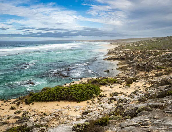
INCREDIBLE VALLEY VISTAS
Once past the gorge, the trail opens up into a wide valley flanked by ranges on either side. For the next 8km you traverse the valley floor. Absolutely stunning!

Without a doubt, this stretch of the Larapinta Trail was one of the highlights for the husband. He loves a good valley view and this is as good as it gets.
Going east, the trail is slightly downhill through the valley but there is very little shade along this stretch so it’s still tiring. By late morning, we were getting cooked yet again.
We crossed Pioneer Creek (lovely sandy campsite here) around 11:30am, and I decided that even if it was a bit early for lunch, this spot would do since this was the first bit of decent shade we’d found in a while.
The area around Pioneer Creek showed the first signs of being burned in bushfires earlier in the year.

From Pioneer Creek it was ‘only’ 7km to Serpentine Chalet Dam, our campsite for the night. But between us and the campsite was a lot of exposed trail and a lot of sun. Having had lunch I felt I had enough energy to soldier on but the sun soon made me wish I was much closer to the end than I was.
Inarlanga Pass, a sacred Aboriginal site, couldn’t come soon enough as far as I was concerned. By the time we got there, I didn’t have a lot of capacity for admiring the gorgeous cycads and flourishing ecosystem in the gorge.

Fortunately, we had been here before so I didn’t feel I was missing out by not having the energy to explore.
THE NEVER-ENDING LAST TWO KILOMETRES
Once you’re through Inarlanga Pass, it’s another 2km to Serpentine Chalet Dam. These last two kilometres seriously felt like they went on forever.
I had run out of water now, I was tired and in desperate need of a toilet so my mood wasn’t the best. In fact, I was at a real low point and had enough. Eventually, we spotted the trailhead shelter from afar and I almost ran the last 500m.
I was exhausted and relieved that Section 9 was done.
We set up our tent across the (dry) creekbed, ending up all by ourselves on that side of the camping area. There were four other hikers at Serpentine Chalet Dam that night but they all chose to sleep in the shelter.

AFTERNOON NON-ACTIVITIES
Since we got here relatively early (about 1:30ish pm), we had enough time to do nothing, followed by a look at the man-made attempt to build a dam.
Side trip: Serpentine Chalet Dam (200m, one-way)
From the campsite, it’s a quick walk to a man-made dam, built in the 1960s. The idea was to supply water to Serpentine Chalet a bit further down the road but given the hare-brained scheme that it was, it was soon abandoned. Now there’s only a semi-permanent waterhole left, a concrete wall and an area filled in with sand and rock.
We’d been to the dam two years earlier on a road trip so I was fine with the dam not looking amazing in the afternoon light. We really only walked up because the husband needed a swim after two hot days of hiking.
I can’t say that the waterhole looked very inviting, and just when he was about to jump in the water, one of the Larapinta guided tour groups arrived.
We suddenly found ourselves surrounded by 20 or so day hikers. Hm.

So no swim, only stinky underarms.
Instead we went back to our campsite to get ready for the next day, which in reality meant taking flower photos and the husband talking to fellow hikers for an hour.

Dinner and bed were reasonably early again as we wanted to have yet another bright and early start up to Counts Point the next morning.
DAY 6: SERPENTINE CHALET DAM TO SERPENTINE GORGE (13.8KM) | SECTION 8
Section 8 is another tough section, though definitely not the toughest on the trail. It’s an ‘up, over, and down again’ affair and that over a relatively short distance (13.8km).
By Day 6 we were starting to get good at getting up around 4:30am. The night had been balmy and calm, and I felt nicely rested.
We’d heard a bunch of the guided group hikers from the day before traipse past the camping area at 2:50am. They were going west and doing Section 9 in one day. Imagine walking in the dark for four hours as sunrise wasn’t until 7:20am! We like to start early but that early?! How much sleep would you actually get the night before?
Anyway.
Pack up and breakfast were quick since it was warm (like 12-14°C) and dry, and by 6:30am we were on our way. First light was coming up fast and so we only needed our head torches for the first 10-15 minutes.
CLIMBING UP TO COUNTS POINT
The trail is initially quite flat through rolling hills and mulga forest (a couple of campsites here) but at about the 4km mark it starts to wind up and around a deep ravine known as Lomandra Gully.

From here, the trail starts to climb and climb. You can actually see the ridgeline on this ascent, which made me feel slightly daunted.
But I had made it up to the ridge two days earlier and I was carrying less food and less water so in-between many puffs and stopping to catch my breath I kept telling myself ‘I can do this, I can do this’.
I’d thought that it would be awesome to get up to Counts Junction by 9am so there might still be a hint of morning light but the husband wasn’t quite as optimistic and thought 9:30am would be much more realistic.
But then we stood at Counts Junction at 8:45am, and I was rightly impressed with myself (especially given chronic health issues). 🤩 (Needless to say, the husband was very happy too.)
From Counts Junction it is another 700 metres to Counts Point, and it is all uphill as well. We dumped our packs at the junction, had a quick snack and almost hopped and skipped off to Counts Point without our packs on (though it still seemed to take forever to get there).
Counts Point is stunning. The views are simply breathtaking.

And the slightly incongruous bench (Friends of the Larapinta, thank you!) makes it even more special. How did they even get it up there?!

We spent far too much time at Counts Point, not least because our three Tasmanian hiking buddies caught up to us and we chatted for ages.
From Counts Point it was back to Counts Junction to make our way across the crest. This ridge felt slightly wider than the previous one at Mount Giles Lookout but the views were just as incredible.
From Counts Junction, it’s about 3.5km across before the (steep) descent starts.
WEATHER UPDATE
Unlike on previous days when we’d hardly seen anybody, today we met quite a few hikers, among them two rather large guided groups. (I find the guided groups slightly annoying since you have to side step and let some 20 or so people pass, sometimes in awkward spots. They make the trail seem really busy and loud. But I digress.)
That said, not having any way of checking the weather (since my ‘Telstra second-class’ phone provider provided me with nothing), I had been taking every opportunity to harass tour guides asking for weather updates.
Today’s weather update wasn’t very favourable with rain coming in the next few days.
When ‘rain’ was first mentioned to us a few days earlier, I’d brushed it off as ‘Alice rain’, a bit of pitter patter and then it’s gone again. Fine.
Now the forecast was for 30-60ml in a couple of days’ time.
We were stunned as the news sunk in. We were so NOT prepared for 30-60ml of rain in a single day. We had not brought proper rain gear, only rain jackets (and in fact, I’d only brought my light rain jacket). This was the desert after all!
While it does rain in the desert, even in winter, it’s usually light rain, not torrential. And not for a whole week. Of course, we later learnt that we would be caught in a rather unusual weather event that soaked much of Central Australia.
So as we descended the range, we debated the merits of staying at Serpentine Gorge or moving on, possibly trying to out-run the weather.
DOWN HEAVITREE RANGE
We continued to make our way across the ridge and then started a rather steep descent with tight zigzags and lots of loose rocks on the trail. Out came the hiking poles again to help with balancing across the rocks.

Once you come to a saddle (with a very small campsite), apparently known as Eagle’s Landing, you’ve done the hard part. From here, the trail continues to wind down but it’s less steep and slopes more gently over hills. We actually put our hiking poles away at this point.
The downhill section is about 4km with the last 2km being painfully slow again. I don’t quite understand how that works. You see the markers and you think you’re almost there but then you’re still 30-40 minutes away. Makes no sense to me.
At long last, the food drop container came into sight, and we breathed a sigh of relief. We met our Tassie friends here again but while we had decided to stay at Serpentine Gorge for the night (we did have a rather large food drop to sort out), they were moving on to Ellery Creek North.
SERPENTINE GORGE FOOD DROP
If you’re coming from the west, the blue food drop container is hard to miss. It sticks out like a sore thumb. If you’re coming from the east, walk up to the carpark, pick up the trail west of the information board and there it is.


I had organised a gear retrieval for this box so our food drop wasn’t a simple ‘grab and go’. I had packed spares (e.g. toilet paper, panadol) that we didn’t need, and then there was stuff we wanted to swap (e.g. camera batteries, power bank) or dump (e.g. extra food, dirty socks).
So we spent a good hour sorting out our food drop box before moving on heavy-laden and with badly packed packs to the Serpentine Gorge camping area. It’s only another 700m to the camping area from the trailhead / food drop but in the late afternoon heat, it seemed a looong way.
Since I had swapped out socks, I’d put my sandals on and was also carrying my boots in my hands now. They are incredibly heavy when they’re not on your feet!
AFTERNOON AT SERPENTINE GORGE
Since we’d been to Serpentine Gorge before, we didn’t feel the need to climb up to the lookout again (and oh, was I grateful that we’d already been there!).
Side trip: Serpentine Gorge Lookout (700m, one-way)
From the campsite, follow the Larapinta Trail west and turn right towards the gorge. The path to the lookout follows 200m later. It’s a fairly steep climb but the views into the upper gorge are fantastic. Definitely worth it if you have the energy.

So instead, we just spent the afternoon in camp, setting up our tent in exactly the same campsite we did two years earlier on our Ellery Creek loop hike (for once it was a quick decision 😁).


I did some washing, sorted out our copious amounts of food (6 days’ worth), snacked, charged devices at the shelter, and prepped for the next day. We had meant to put a few more things back into our food drop box (after sorting) but by the time the husband made it back to the container, our box had already been retrieved! On a Sunday. What efficiency.
We meandered up to the rockpool at the base of the gorge in the late afternoon (about 400m one-way) so we at least saw something. There’s no swimming here, it’s a sacred Aboriginal site.


I don’t remember if we went to bed early that night, I assume we did. I do remember that it was the warmest night on the trail and when we got up the next morning it was already 18°C at 6am.
TIPS FOR SECTION 9 + 8
The main thing to know about Section 9 and 8 is that you climb up to a ridge, traverse and hike down again. The views are spectacular and if you want to camp up the top, you’ll need to bring adequate water.
Here are few other post-hike thoughts on Section 9 and 8:
- There are multiple options for camping along this stretch but most of them require water carries so make sure you’re prepared for that. Most of the campsites are on hard dirt (lots of rocks/pebbles so use a footprint).
- Section 9: A couple of small campsites (you might just get a 2-person tent on them) along the trail to ‘Base of Hill’ before the ascent starts; a few campsites when you’re almost at the top of the ridge (facing south) but not much shade here; great camping spots at Hermit’s Hideaway, they’re fairly close together so if busy it could feel ‘tight’; 3-4 campsites at Mount Giles Lookout, completely exposed; 4-5 campsites past Waterfall Gorge, didn’t look that flat to us but we didn’t check them out closely either; 1-2 sandy camping spots at Pioneer Creek, some shade; no other campsites (that we noticed) between Pioneer Creek and Serpentine Chalet Dam (about 7km)
- Section 8: 2-3 campsites in mulga forest (about 2-3km from the Serpentine Chalet Dam trailhead); a couple of small campsites near Lomandra Gully on the first knoll (facing south); 1-2 campsites at Counts Junction (not the flattest); 3-4 small campsites at Counts Point, two with nice rock walls, the rest looked less appealing, all quite tight; 1 campsite at Eagle’s Landing (saddle following the descent at the other end of the ridge)


- Mobile reception for Telstra (but not second-tier providers) is possible on both ridges, 3G only; mine didn’t work
- USB-charging (5V) worked fine at the shelter at Serpentine Gorge; cables and box missing at Serpentine Chalet Dam (it was clearly there at some point given the hole in the cupboard)
- If you’re doing Section 9 over two days, carry at least 6 litres of water per person, more if it’s warm/hot. We rationed our water and I still ran out (in the middle of winter) before we got to Serpentine Chalet Dam. Hydrate well before and after.
FURTHER READING
I’ve also written a general overview and post-hike thoughts on the Larapinta if you’ve missed that. Or you can delve into the first few days hiking from Redbank Gorge to Ormiston Gorge if you haven’t seen that yet.


2 Comments
Alison van der Schans
27 April 2024 at 10:45 PMThanks Katie for what seems a very honest and fascinating description of the walk. I plan to do this in June and have been trying to work out why commercial trips and even the suggested time frame for pick ups are around 14 days total and yet the section guide states allow 20 days for an end to end walk. Not interested in 29km that means I fall into my tent and see nothing at the end of the day. I will reconsider packing my better wet weather coat I think after reading your posts. Really great photos too.
from Alison.
Kati
28 April 2024 at 12:07 PMHi Alison,
Thank you for your lovely comment, it’s really nice to hear that my recounting is actually useful (which also made me realise that I never finish my tale and only described the first part).
June will be a perfect time to do the Larapinta and I don’t think you need to worry about rain too much. It was a bit of an unusual rain event last year. If we did the hike again, I still would pack the same light rain jacket and no rain pants (unless there was some serious downpour forecasted just before leaving). And yes, people take anywhere from 7 days (how??) to 21 days, it’s really up to you. We would plan even more time next time, around 18-19 days is probably perfect if you want to plan some lay days, have a full day for the Ormiston Pound walk and enjoy yourself. 🙂
Happy hiking!!!