
This post contains affiliate links. If you buy something through these links, I may earn a small commission at no extra cost to you. I only recommend gear I’ve actually used out on the trails and really loved! Read my full disclaimer.
It’s not easy to book a permit to hike the Milford Track, New Zealand’s most popular Great Walk.
We’ve booked it twice (and had to cancel once because the pandemic got in the way…). Both times we had to be incredibly fast. It was less than 10 minutes the first time, and less than a minute for the second time before all the dates were gone!
Luckily, we could keep our second booking and actually hiked the Milford Track.

The Milford Track takes you through towering fjord valleys, past wild rivers, gushing waterfalls, lakes, and over an alpine mountain pass. And all of this without any sign of civilisation beyond the obvious track facilities.
[NOTE: You can also hike the Milford Track as a guided walk with individual rooms, showers and cooked meals. I’m not quite at a point in life where I want to fork out $3,000 a person to do that. I can see how a guided walk might have appeal, and it may, in fact, be the only option you have for doing the Milford Track if you’re constrained by specific dates or don’t have all the hiking gear.]
This is a very long post, maybe get a cup of tea first. 🙂
THE MILFORD TRACK: WHAT TO KNOW BEFORE YOU GO
📅 2026/27 SEASON BOOKING ALERT
Bookings for the Milford Track open on Wednesday, 13 May 2026 at 9:30 AM NZST (7:30 AM AEST). These spots usually vanish within minutes. Make sure you are logged into your DOC account before the virtual lobby opens to secure your place in the queue (I know, crazy!).
The Milford Track is without a doubt one of New Zealand’s best walks. We would do it again in a heartbeat.
Tucked away in Fiordland National Park on the South Island, the Milford Track is a rare treat in New Zealand where you tend to see signs of civilisation everywhere (houses, farms, sheep, fences, roads, you name it).

But on the Milford Track, I felt a million miles away from it all. It’s like you get dropped into the wilderness – it’s literally just you and Fiordland (and a few other hikers).
Unlike the nearby Routeburn Track, the warmer Abel Tasman Coast Track or the Queen Charlotte Track in the Marlborough Sounds, all of which you can slice and dice to suit your needs, the Milford Track is a very structured multi-day hike.
THE MILFORD TRACK AT A GLANCE

THE ROUTE: A ONE-WAY HIKE
You can only hike the 53km/4-day Milford Track in one direction, from Te Anau Downs to Milford Sound.
There’s no camping along the trail and you have to stay in each hut for one night. There’s no skipping of huts because you feel you might hike faster and want to tackle the trail in three days or less.
There are 40 bunk beds in each hut, and you will basically hike and live with the same group of hikers for four days.

Transport-wise, you need to organise boat shuttles at both ends, and either a car shuffle (or car relocation/pickup) to Piopiotahi/Milford Sound or a bus transfer back to Te Anau or Queenstown.
But beyond the weather, organising your transport options, being in reasonable shape and having done some hiking before, and packing appropriate clothing, there isn’t much you need to consider for the Milford Track.
ELEVATION PROFILE: FLAT VALLEYS & ONE BIG CLIMB
The Milford Track is fairly straightforward. For the most part, it’s a wide, open track that’s either slightly uphill or flat.
The only day you need to ‘worry’ about is Day 3. You’ll have both, a long ascent and a very drawn out descent.

The first two days are comfortable, with Day 1 being particularly easy.
Day 3 hits you with a steep ascent to Mackinnon Pass in the morning, followed by an almost 1,000m drop in elevation over eight kilometres once you’ve crossed the pass.
It’s not a long day in terms of distance but it’s hard. That’s the day you’ll be really exhausted. And the day you curse your ITB or knees.
Day 4 is flat-ish again.
BEST TIME TO HIKE THE MILFORD TRACK
Being in the same Southern Alps vicinity as the Routeburn Track and Kepler Track, the Milford Track is best attempted during the Great Walks season (late October to late April).
Fiordland gets some 200 days of rain a year so chances are pretty high that it will rain while on the track. You can only hope and pray that it won’t be torrential rain.

Weather conditions can make this track very challenging during the winter months.
There’s very little daylight and freezing temperatures in the narrow Clinton Valley during winter. The rivers can be gushing and bridges across the Clinton Valley are removed in June, making river crossings dicey (people have died). There’s a risk of avalanches and snowy conditions across the pass.
Plus facilities in the huts are greatly reduced (e.g. no cooking gas, no flushing toilets, no mats) during the off-season. It is much cheaper though.
You’ll also have to find a boat operator that will take you across Lake Te Anau. Some hikers just go to Milford Sound and then hike to Dumpling Hut from Sandfly Point, stay the night and hike back.
PRACTICALITIES FOR HIKING THE MILFORD TRACK
Here are a few things to keep in mind when planning your hike.
GETTING A PERMIT
Key consideration: Actually getting a spot on the Milford Track is the hardest part.
Check the dates for when the DOC booking system opens: For the 2026/27 season, bookings open at 9:30 AM NZST on Wednesday, 13 May 2026.
Some practical tips for booking:
- Be ready to book on the dot: Log into your DOC account early so you can secure your spot in the new virtual lobby before bookings even open! Most people just end up with whatever dates they can snatch up and take it from there.
- Check for cancellations: If you’ve missed out, keep checking the DOC booking system; people do cancel all the time—you might be lucky, especially if you’re a solo hiker and benefit from someone else’s cancellation.
Fees vary depending on the season and whether you’re considered residing in New Zealand or not. For the 25/26 season, the fee for international hikers during the Great Walks season is NZ$152 p/n.
For more information, including the most current fees, check the DOC Milford website.
TRANSPORT LOGISTICS: THE “WATER SANDWICH”
Unlike other tracks, there aren’t any route decisions to make on the Milford during the Great Walks season, so your main hurdle is the logistics.

Because it’s a point-to-point walk that requires water crossings at both ends, you have to coordinate your timing between road and water.
We used RealNZ for our boat shuttles on the Milford Track but have also used Tracknet for bus transfers in the past and found them super flexible when our plans shifted. RealNZ gave us a time window for the Sandfly Point-Milford Sound water taxi instead of a fixed time (2:30pm to 4:30pm), which made our last day fairly relaxing.
MILFORD TRANSPORT OPTIONS
Boat shuttles: You need a ferry/water taxi at both ends: Te Anau Downs to Glade Wharf (start) and Sandfly Point to Milford Sound (finish). Outside the Great Walks season, these are much harder to find; May is your best bet before the weather gets properly extreme.
• Cost: Approx. NZ$150 per person (total for both boats)
• Operators: RealNZ or Tracknet
Bus transfers: The easiest way to link Queenstown or Te Anau to the ferry points. You can often book your bus and boat as a combined package to save on the admin of dealing with multiple companies.
• Cost: Approx. NZ$60 – $150 per person (depending on the route)
• Operators: Tracknet or RealNZ
Car relocation: This is what we did. You drive to Te Anau Downs and your vehicle is moved to Milford Sound while you’re hiking. It’s the most expensive option but it means you can drive straight out once you get off the final water taxi.
• Cost: Approx. NZ$330 (+ fuel)
• Operators: Trackhopper or Easyhike
Note: We had our campervan relocated from Te Anau Downs to Milford Sound by Trackhopper and had zero issues. But it was still a huge relief to see your own van waiting for you at the end!
HUTS AND ACCOMMODATION
During the Great Walks season, the facilities in the huts are fantastic:


- Cooking facilities: Gas stoves provided in all huts but bring your own pot and bowl/cutlery.
- Cleaning liquid: Available in all huts, which doubles as dishwashing liquid. Some also have cleaning cloths but we always bring our own to avoid any food contamination and because sometimes they can be a little on the unsavoury side.
- Filtered water: Available.
- Sleeping mats: Provided. Only Mintaro had new mats while the other two huts had fairly old ones. The mats at Dumpling Hut were really worn out and in dire need of replacing. DOC has probably replaced them by now.
- USB charging points: A few available at Mintaro Hut (Day 2).
- All the huts have solar-powered lighting and fireplaces that are lit by the rangers.
WHERE TO STAY IN TE ANAU & MILFORD SOUND
Te Anau is a busy tourist stop, so don’t leave booking too late. While there is plenty of choice, accommodation can fill up fast.
Here are the spots where we’ve stayed in the past:
• Te Anau Lakeview Holiday Park: We stayed in a one-bedroom studio here. It was adequate for a night. It’s budget-friendly with heaps of options, including more upmarket motel-style options. It’s a fair walk into town but very convenient for doing the Kepler Track as you’re right on the doorstep.
• Milford Sound Lodge: Your main option if you want to stay at Milford Sound (there are not a lot of options!). They have reasonably nice campervan/caravan sites and rather pricey but lovely cottages, but they don’t offer tent-based camping.
You can also browse other Te Anau accommodation here.
TOILET ACCESS
New Zealand is amazing when it comes to toilet access on these popular walks.
There are obviously toilets at each hut but also at each shelter (except Bus Stop Shelter) at regular intervals along the track (see above map). There’s really not much need for bush toileting, which is also tricky given how many hikers are constantly on the trail.

The only problem we had when we hiked the Milford Track was the toilets at Prairie Shelter between Clinton Hut and Mintaro Hut being full and unusable (and awaiting their helicopter pickup). We were allowed to use the toilets at the guided walkers’ hut though.
I always bring a Kula Cloth and extra toilet paper but it wasn’t needed.
OUR TRIP LOGISTICS (AND WHAT WE SPENT)
Here’s how we organised our Milford Track hike:
- Campervan relocation: Organised campervan relocation to Milford Sound with Trackhopper. We drove our van to the carpark at Te Anau Downs on the morning of Day 1, and picked up our campervan at Milford Sound our days later. We then stayed at Milford Sound Lodge for another two nights.
- Boat shuttles: Organised boat transfers with RealNZ to Glade Wharf (start) and from Sandfly Point (end) to Milford Sound; caught the boat to Glade Wharf at 2pm on Day 1 and then another boat shuttle from Sandfly Point at 3:00pm-ish on Day 4
ESTIMATED COSTS (2026)
You can’t really do the Milford Track on a budget unless you decide to go outside the Great Walks season, and hope for the best at the huts (they’re ‘first come first served’ in the off-season).
It might seem expensive but it really is worth the cost. It is an amazing hike!
We spent:
- Milford Track DOC permits: NZ$110 pp/pn (international visitor) (2026: NZ$152)
- Boat shuttles (round trip): NZ$298 (2026: NZ$149 pp)
- Campervan relocation: NZ$299 (2026: NZ$330)
- Total: NZ$1,257 (~AU$1,130) (2 people)
Added to that was the food we bought / brought into New Zealand pre-hike and the campervan rental days.
WHAT TO PACK: ESSENTIAL GEAR FOR FIORDLAND RAIN
It always feels like a much easier hike when you don’t camp but somehow my pack is still always very full. I keep chipping away at it but I’m very far from calling it lightweight.
Beyond the must-have rain gear, here are a few things that were useful on this hike:
MILFORD TRACK GEAR GUIDE
4-DAY MILFORD TRACK ITINERARY & TRIP REPORT
We hiked the Milford Track in early April, not having a lot of choice when frantically booking almost a year earlier. It was reasonably fresh in the mornings but still warmed up during the day.
The only time it was bitterly cold was when we crossed Mackinnon Pass on Day 3. The rest of the time was very comfortable; perfect hiking weather really.
DAY 1: TE ANAU DOWNS (GLADE WHARF) – CLINTON HUT | 5KM (WITH SIDE TRIP: ~5.5KM)
Day 1 starts with a very gentle walk. That is, if you’re not walking in pouring rain and wading through knee-deep water.
Like on most of our hikes, the first day offered less than stellar weather to us. We woke up to low clouds, fog and drizzle, which turned into reasonably heavy rain by lunch time. Our boat ride across Lake Te Anau was at 2pm, but thankfully, most of the torrential rain had passed by then.
We left our campervan in the carpark at Te Anau Downs to be relocated to Milford Sound while we were hiking the trail.

Once you land at Glade Wharf (about an hour later), it’s time for the obligatory start-of-the-great-walk photo, followed by a rather uninspiring trek down a rough 4WD track to Glade House.
This is where today’s hike ends for guided walkers. For us, it was another four kilometres before peeling ourselves out of our wet weather gear.


The Milford Track is a very well-made track so there aren’t really too many ‘technical’ challenges.
But it still took us longer than expected as we encountered a fair bit of flooding on the track, and I wasn’t really that keen to get my boots completely submerged just yet. So lots of wading around the flooded sections and pools.
FIELD NOTES: THE RAIN JACKET
Fiordland rain is on another level, so a decent rain jacket is kind of important. I’ve been using the Patagonia Torrentshell 3L lately; it’s a solid jacket that actually keeps the water out without too much of a “plastic bag” feel. The pit zips are a bit lost on me but people really do love them (the husband included), and it’s tough enough to handle being shoved in and out of my pack all day.
Check out the Patagonia Torrentshell 3L →
You can see the rest of the gear I use to stay dry and happy on my full gear list.
All in all, it was about 1.5 hours of walking on Day 1.
Luckily, given the rain, Day 1 is almost entirely in beech forest so you get a fair bit of protection from the elements as you hike along the Clinton River.

Just before you get to Clinton Hut, there’s a short wetlands walk into a clearing. Even with the low clouds, drizzle and fog swirling about, I found the moody scenery just beautiful.
CLINTON HUT
Given how wet it was, I was very happy to get to Clinton Hut.
The hut has definitely seen better days, especially the mats (please replace!), but it’s not the worst either. As far as huts on New Zealand’s Great Walks go, Clinton Hut isn’t in the most picturesque setting. But this is New Zealand so there is still a mountain backdrop with waterfalls streaming down.
There are only two bunkrooms with 20 bunk beds each, making for pretty noisy bedrooms.
In fact, we had the worst snorer of our entire hiking history in our bunkroom. He was so incredibly loud that the walls were shaking! Let’s just say that no sleep was had until we dragged our mats into the common room around midnight (along with a couple of younger fellas who equally found sleep in an industrial-level snoring setting elusive).


The common room at Clinton Hut is rather squishy, and I’m not sure that all 40 of us even got a seat. Some had to crouch on the floor during the nightly ranger talk.
If you get an earlier boat ride, you’ll have all afternoon to explore the riverbanks and maybe even go for a refreshing swim in the summer. In early April, it was definitely too cold for that.
SIDE TRIP: WETLAND WALK
The Wetland Walk is a very short detour, about 10 minutes.
We did it on our way to Clinton Hut, mostly because it was so wet. But you could just as easily walk back from the hut.
The boardwalk takes you out into a bog (= swamp) from where you have almost 360° views of the surrounding fjord cliffs.

DAY 2: CLINTON HUT – MINTARO HUT | 17.5KM (WITH SIDE TRIPS: ~18KM)
After the rather short walk on Day 1, the next day is a proper hike taking you from Clinton Hut to the fabulous new Mintaro Hut.
Day 2 was our favourite day on the Milford Track.
The rain had stopped overnight and the clouds were no longer obscuring the valley quite as much. But it was still a bit gloomy in the morning.
It was supposed to clear up later that day so we still took our time and didn’t leave the hut until just after 8am (very late for us).

The track winds its way through the magnificent Clinton Valley as you inch closer and closer to Mackinnon Pass.
Much of Day 2 feels like you’re wandering through a Jurassic wonderland. It’s lush and awe-inspiring, and my photos don’t do the majesty justice (not to mention the challenge of walking into the sun for most of Day 2 and 3 and attempting to take photos).
You follow the Clinton River for most of the day, hemmed in by sheer cliffs and cascading waterfalls. I felt a bit like a tiny ant dwarfed by majestic fjords surrounding us.


And even more precious, there’s not a hint of civilisation in sight.

We spent so much time marvelling at the cliffs and the Clinton Valley stretching out around us that we took much longer to hike the distance that we normally would, getting to Mintaro Hut around 3pm.
There are plenty of bridges on Day 2, with some across rocky, almost dry tributaries. With sufficient rain and/or snow melt, I imagine these creek beds would turn into gushing monsters and crossing them without a bridge in place would not be fun (not to mention dangerous).

Day 2 is a gradual uphill but it’s really not that noticeable until you reach Bus Stop Shelter (which, indeed, looks like a bus stop shelter, albeit more spacious).
There are a couple of very short detours along the way that are worth doing.
The first one is at the start of the ‘prairie’ section taking you to the small Hidden Lake. It’s not particularly exciting.


Much nicer and potentially a good spot for lunch, depending on what time you get here, is Prairie Lake with its cascading waterfalls.
Prairie Shelter is at the end of the prairie section with toilets that were closed for us (due to being full and unable to be picked up until a few days later). This would be another good lunch spot.
We continued on to Bus Stop Shelter, a couple of kilometres further on to have lunch (no toilet here).


Just after the bus stop is the giant rocky river crossing (mostly dry for us) over Marlenes Creek. It can be too dangerous to cross in heavy rain or flood conditions – hence Bus Stop Shelter with plenty of space to wait out adverse weather conditions.
From this shelter it’s another five or so kilometres to Mintaro Hut.


It almost seemed a bit silly not to wait until we got to the hut to have lunch. But with the rest of the track starting to be noticeably uphill and my blood sugar levels getting low, I’ve suffered valuable lessons in the past. Stop and eat, rather than push on.
There’s another very short side trip (it’s basically a ‘side step’ it’s so short) to Mintaro Lake, the source of the Clinton River, just before Mintaro Hut.

As so often, the last kilometre seemed ridiculously long but at least it was through gorgeous moss and fern-covered forest. Lots of rock stepping too though.


Once you hit the swing bridge (past Mintaro Lake), you’re pretty much at the hut.
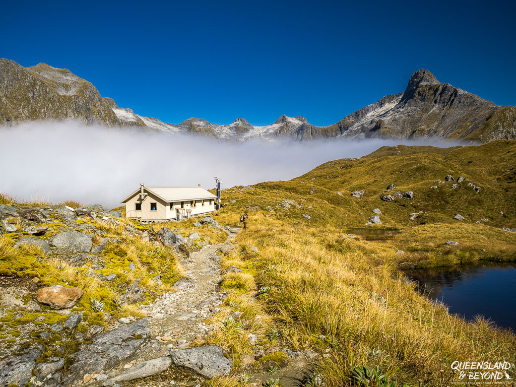
MINTARO HUT
New Mintaro Hut, rebuilt during the pandemic, is amazing.
With double-glazed, huge windows and a beautiful fireplace, the common room is fabulously warm, spacious and light. It’s got a great wrap-around verandah and bunkrooms that sleep about eight each (and with cubby holes for your pack etc.). And new, thick, comfy mats. Ah, *sigh*.

There are so many stoves in the two kitchen areas that there’s not really any jostling to cook your meal at night.
Whilst we managed to avoid the super snorer, we scored well again, having two new (though less deafening) snorers in our bunkroom that night. So we slept in the very toasty common room again.
SIDE TRIPS
Apart from the short side trips to the various lakes in the Clinton Valley, it’s worthwhile to traipse to the Blue Pools, just around the corner from Mintaro Hut.


The water is icy but if you’re game or it’s warm enough, a swim is probably super refreshing. We heard three young guys jumping in, with much carrying on, that is.
If you wanted a bit more of a stroll and you didn’t stop there along the way, walk back to Mintaro Lake. It’s not far from the hut, and it’s where the helipad is (makes for a nice viewing platform).
DAY 3: MINTARO HUT – DUMPLING HUT | 13KM (WITH SIDE TRIP: ~19KM)
The overall distance for Day 3 might not seem like much (13km). But… with a 500m climb in elevation to wake you up in the morning, followed by 1,000m drawn-out drop in elevation to make you regret coming on this hike, this day is no walk in the park.
The morning of Day 3 was again very foggy so we were in no hurry to leave comfy Mintaro Hut, getting on our way just after 8am. The views into Clinton Valley were largely obscured by fog and we only got glimpses of what lay behind us.

Since my cardio fitness isn’t amazing, I huffed and puffed uphill, finding it quite challenging.
Despite the 500m gain in elevation, this section isn’t steep per se. It’s just a long, rocky zigzag up to Mackinnon Memorial. The husband didn’t think too much of it while I had to stop frequently to catch my breath.


On the other hand, the husband (and others like him) thought the 8km-downhill later was a killer and no fun at all. I thought it was great (though tiring) since I can usually just run downhill as long as I’m smart about where I put my feet and take the weight out of my knees.
So Day 3 has something for everyone! 😀
We got to Mackinnon Memorial, dedicated to explorer Quintin Mackinnon, in just under two hours, shortly before 10am and still completely clouded in fog.

From the memorial, it’s another two kilometres across the pass (highest point: 1154m) to Mackinnon Pass Shelter. I have rarely walked this fast!
Luckily, the fog was just starting to clear, presenting us with stunning panoramic vistas across the pass and into the steep fjord valleys surrounding us.
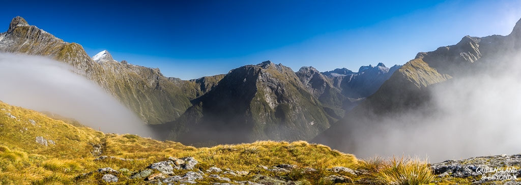
This shelter is amazing: It has a gas cooker and is fully enclosed to keep you warm from the absolutely freezing wind and temperatures across the pass. I had brought some powdered vegetable broth and that was perfect for bringing the icy chill in my body to more manageable levels.
MY TIP: Leave your cooking gear towards the top of your pack if you want to have a cup of tea and don’t fancy unpacking your whole pack. Ours was fairly deeply buried in the husband’s pack but we got to borrow someone else’s to boil some water for our veg soup.
From the shelter, it’s a further short icy stroll past pristine alpine tarns, waves of tussock grass and craggy, snowy peaks before the descent into the forest begins. It quickly gets warmer again as you’re no longer exposed to the freezing Antarctic winds.

The track snakes around the other side of the pass before eventually dropping to the valley floor. You hike alongside Roaring Burn for a while and past some gorgeous waterfalls and cascades.

Along this section of the trail are boardwalks, rocky bits and oh-so-many steps so anyone with knee issues will likely not appreciate this part.
It is long but also very pretty.
We ended up having lunch at Andersons Cascade Shelter, a lovely sunny spot halfway down. We had a little mishap here so I forgot to take photos of the shelter.
Past Andersons Cascade Shelter, you continue to zigzag down the slopes to Quintin Shelter.


Once you’re at the base, you can take the detour to thundering Sutherland Falls.
The falls are actually best viewed from afar as you can’t see them in their impressive glory once you’re up close. They are roaring with spray flying everywhere and you just end up being soaked.

The last few kilometres of Day 3 were not overly exciting but mostly because our human needs took over. We were tired from all the downhill hiking, the husband was limping and I was very hungry.
FIELD NOTES: HIKING POLES
I don’t always use poles, but they were quite the help for the 1,000m descent from Mackinnon Pass. These Black Diamond ones are light enough that you don’t really notice them on your pack for the flat valley walks, but they definitely helped me get down the rocky downhill sections of Day 3. They aren’t exactly cheap, but they’re sturdy and pack down small enough to be worth the space.
Check out the Black Diamond Distance Carbon Z Poles →
You can see the rest of the gear I use to keep my joints intact on my full gear list.
By the time we actually got to Dumpling Hut (just before 5:30pm), I was well and truly done and didn’t want to take another step. It had been a long day.
DUMPLING HUT
Dumpling Hut is on the older side, a lot more like Clinton Hut, and very unlike shiny, new Mintaro.
The mats here were exceptionally well-loved and I can only hope that they got replaced the following season. We may as well not have had a mat at all.

Dumpling has a nice big common room with a whole corner dedicated to photos and copies of historical documents along its walls. It ‘s quite fascinating to read what people thought of the Milford Track when it first opened in the late 1880s.
Dumpling Hut sleeps about 10 people in each bunkroom. It was the only hut where we scored a bunkroom full of quiet people! And so we actually slept in our bunks for once.
SIDE TRIP: SUTHERLAND FALLS
Taking a side trip to Sutherland Falls almost seems like a bit too much effort once you get to the turnoff but you cannot not take it.
It’s New Zealand’s highest waterfall with a drop of almost 600m, and one of the highest in the world.


The side trip is about 6km return but you can leave your pack at Quintin Shelter. There are some steep-ish sections on this side trip and doing it at the end of an already long day certainly added to the challenge.
Make sure you bring your rain jacket or you will get very wet if you hike all the way to its base. It’s astonishing how deafening a waterfall can be!
I couldn’t take any clear photos up close as the spray is just too nuts.
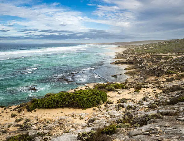
DAY 4: DUMPLING HUT – MILFORD SOUND (SANDFLY POINT) | 18KM (WITH SIDE TRIPS: ~18.5KM)
Day 4 gave us absolutely cracking weather, bright blue sky and not a cloud in sight.
This seemed very odd on the Milford Track but then we are generally blessed with incredible weather on our New Zealand trips (disregarding our most recent trip, which fell squarely into the bad weather category…).
The last day on the Milford Track is mostly flat, following the wide Arthur River for pretty much the whole day.
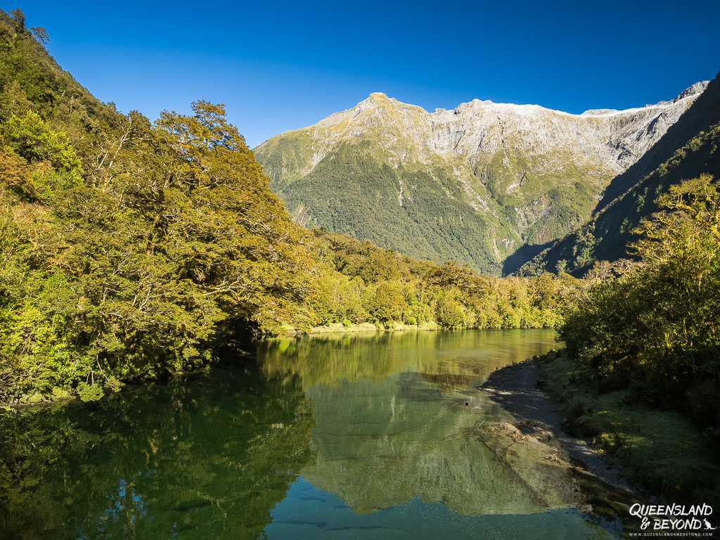
There are a few very short side trips on the last day, including to stunning MacKay Falls, semi-interesting Bell Rock and crystal clear Lake Ada.


Although it’s largely flat, Day 4 had a few more ‘mini hills’ than I had expected, making me huff and puff in short bursts. But overall, it’s an easy day.
We also had a giant tree to navigate, which was quite hilarious since I got a bit stuck on it and couldn’t swivel off it with all the laughing I was doing.
The last two kilometres on the Milford Track are probably the least interesting ones on the whole trail, being wide and almost paved like a road.


When you consider that this part of the track was built by convicts in the late 19th century, it makes sense. But by then I was also definitely suffering from “trail end-itis” and couldn’t wait to finish.
Unlike most of the other hikers, we left even later on our last day, around 8:30am since we didn’t have the pressure of catching a bus out of Piopiotahi/Milford Sound.
We took it quite leisurely, had a good lunch break on the river bank at Giant Gate Falls, and still arrived with plenty of time to spare at Sandfly Point (giving the highly irritating sand flies something to munch on while we waited and madly flapped our arms).

We were booked on a boat shuttle from Sandfly Point to Milford Sound at 2:30pm but the boats actually run til about 4:00/4:30pm. We ended up catching a shuttle at 3pm because we’d just missed the 2:30pm one.
As long as you go with the right operator, it doesn’t really matter what time you hop on (provided you don’t have time pressure at the other end).
Our van was waiting for us at Milford Sound so it didn’t really matter for us.
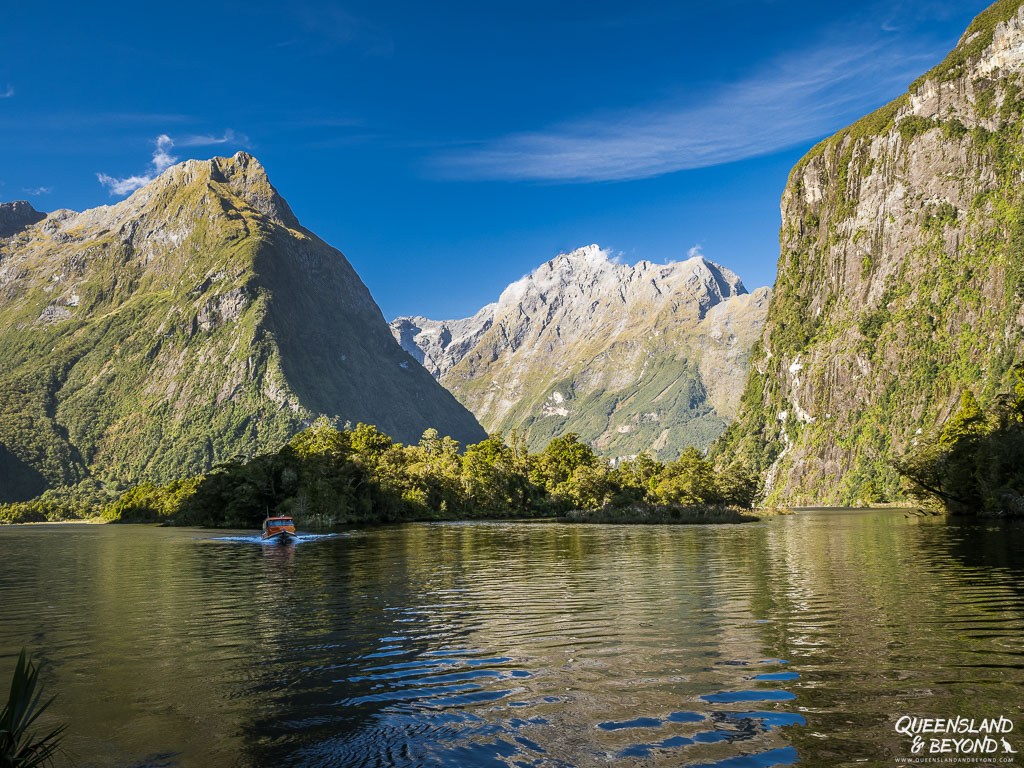
The trip across the sound at the end is short and sweet, and given the weather was a great way to finish our four days on the Milford Track.
I would only say that it was quite a shock to arrive back in civilisation with a few too many tourists milling about the ferry terminal and along the footpaths at Piopiotahi/Milford Sound.
Luckily we found our van quickly and then had two days to decompress at Milford Sound Lodge.
SO, WAS IT THE “FINEST WALK IN THE WORLD”?
Yes. Or at least it’s right up there with the top hikes in our list!
The Great Walk facilities, in general, are fantastic, and in most cases all you need is your sleeping bag, food, clothes and whatever other paraphernalia you bring along.
Despite the rather prescriptive nature, the 4-day Milford Track is, without doubt, one of the best trails we’ve ever hiked. So far it’s only eclipsed by the Larapinta Trail in Central Australia.
Hiking through Clinton Valley flanked by massive fjord cliffs was probably my highlight but I also really enjoyed the cascades of Roaring Burn.

Doing the Milford Track will feel a bit like a group hike since you’re stuck with the same people at every hut. But unlike the guided walks, everyone still does their own thing and people spread out over the course of the day.
If you can steal a spot on the booking system, don’t hesitate.
It’s more than worth it.
Happy hiking,

Planning more multi-day hikes? The Routeburn Track is a spectacular sub-alpine walk and a bit easier to book than the Milford. I’ve written a guide that covers the logistics and side trips like Conical Hill.
For more South Island trips, I’ve also shared day-by-day reports for the Abel Tasman Coast Track and the Queen Charlotte Track. Or, if you’re looking at Australian trails, the Larapinta Trail remains one of my absolute favorites.
POST-HIKE PHOTO THOUGHTS
Somehow I found it quite challenging to photograph the Milford Track and came home with far fewer photos than I usually would (around 250; a 4-day hike would normally lead to something more like 500-600 photos, especially something as impressive as the Milford).
I’m still a bit stumped as to why. Here are a few post-hike thoughts:
- The first day was very wet and gloomy so I didn’t take a lot of photos because the rain was just getting in the way and my hands were super wet. It was also quite dark and my camera isn’t amazing in low light.
- You walk straight into the sun for most of Day 2 and 3, making wide landscape shots difficult. I also found it almost impossible to capture the sheer size of the cliffs in the Clinton Valley. Foggy conditions didn’t help.
- I didn’t take my usual hiking trail shots (at least not to the same extent as I normally do). I don’t know why. Was I too busy looking at the trail?? The scenery around me?? I have no shots of the boardwalk sections on Day 3 or any of the downhill trail, which I’m really annoyed about, as well as no shots of the inside of Mintaro Hut. I remember spending a fair bit of time stretching at Mintaro because my hamstrings and glutes were super tight; I obviously just forgot the photo part (plus I don’t like to have people in them).
- The waterfalls on Day 3 were almost impossible to get a good shot of because you’re constrained by the boardwalk barriers and the steep track / river.
- Sutherland Falls look best from afar (the swing bridge) or just before you come out of the forest. I got completely soaked trying to get a good shot close up and gave up.
- I took remarkably few photos on the last day (except MacKay Falls, but again constrained by a platform), and didn’t even bother with Giant Gate Falls because it was directly into the sun. The sun is mostly in the right spot to offer great shots of the Arthur River and surrounding cliffs.
- I took very few close-ups and almost none of plants. The ones I do have were on my phone.
SAVE TO PINTEREST


6 Comments
Spophy
16 July 2024 at 11:34 PMDer Nebel sieht richtig krass aus!
Kati
19 July 2024 at 9:44 AMJa, der hat richtig schoene Boegen gezogen bzw. ist in so schoenen Schwaden aufgestiegen. Am krassesten war, dass wir oben erst gar nichts gesehen haben und dann auf einmal ging der Nebel weg und voila, die Taeler lagen zu allen Seiten! <3
Graham
25 April 2025 at 10:34 AMJust a few things Its not 2 km across pass from Cairn to Hut. Secondly the track from bottom of Lake Ada was not built by convicts and actually very little of the track was Some were brought in but wouldnt work or were drunk so it was a failure.. We had Borstal boys sent to help us and they chucked the tools in the bush and wouldnt work so got sent back to Borstal. The wide track from Sandfly to Doughboy was built in the late 50’s early 60s to enable the boats to be taken up to the lake We had a punt orginaly then they had to widen it a bit more and put narrower axles on the trailer to take the Hamilton Jet boat up there in 1963. We had two tractors and trailers and the supplys were brought to Sandfly in a dinghy then trailer to Doughboy and boat to Boatshed and then packhorses to Quintin. We had 6 packhorses that were walked in at start of the season and taken out to Te Anau for the winter These finished in 1968 The swing bridge at Boatshed was built in the 80’s or maybe later and prev to that you got rowed across the river in a dinghy ( some days by me)
Kati
25 April 2025 at 11:45 AMHi Graham,
Oh wow, thanks heaps for your detailed comment. Sounds like quite something building and supplying everything with packhorses etc.! I’m trying to imagine getting rowed across the river in a dinghy rather than enjoying the amazing swing bridges of today.
Re. the convicts building the last stretch of the track, I remember the ranger at Dumpling talking about it and it’s also on the DOC website – though admittedly, they speak of “prison labour gangs” not convicts per se who built that part of the track in the late 19th century. I can imagine that it wasn’t a particularly easy feat building a track with labourers sent in who didn’t exactly want to do this, no doubt, back-breaking work. I’ll check what I wrote and clarify as necessary.
Do you know how far it is between the Cairn and the shelter? I didn’t have the exact distance but estimated 2km based on my walking time and mile markers. Is it less and I was just particularly slow across the top?
Graham
27 April 2025 at 9:20 PMHi well i was probably out a bit with the pass distance but it wouldnt be more than a mile as I remember it took about 15 mins to walk it . Yes there were prisoners building parts of the track > But not in 19th century much as track was only discovered in the 1880’s and maybe were on the Sandfly bit but the wide part was done in the late 50’s early 60s when we had a Punt on the lake and from 63 had a Jet boat. . Before we got the Jet we went up river in the punt at about 5mph and had to unload at the bottom of the rapids and carry all the gear up to the top and pull the boat up and reload it again and on to Boatshed Jet stopped that luckily but when the Jet broke down (and it did) Trackhands had to carry the stuff up to Boatshed. mile markers were a guesstimate in my time and just put there to let you know you had progressed somewhat LOL Cant post phot0s as have a lot for 65 years ago
Kati
2 May 2025 at 3:18 PMHi Graham,
So maybe it’s around 1.5km between the memorial and the shelter, and I was very slow or took too many photos (my watch tells me it took me about 25 minutes to walk the distance). 🙂
Gee, wow, sounds crazy building the trail when you describe it like that! I’m sure your photos would be really interesting (you could email me a couple and if you were happy, I could insert them into the post with credit to you? Just a thought…). And yep, I think DOC probably means that prisoners built parts of the end bit, they talk about 1892-93 (I think), definitely wasn’t for long and perhaps they didn’t achieve all that much! 😆