

This post contains affiliate links. If you buy something through these links, I may earn a small commission at no extra cost to you. I only recommend gear I’ve actually used out on the trails and really loved! Read my full disclaimer.
Bunya Mountains National Park is on Aboriginal land. I acknowledge the Traditional Custodians of this area and their connection to Country, and pay my respects to their Elders past and present.
Bunya Mountains: Ancient bunya pines, valley vistas, rainforest, walking trails and wallabies everywhere. Sounds like a great place for a relaxing camping weekend away.
While the Bunyas aren’t our absolute favourite national park in Queensland or even South East Queensland, it’s still worth exploring and hiking the trails. And since they are only about 200km west of Brisbane and cover a relatively small area, a long weekend is all you really need.

BUNYA MOUNTAINS: TIPS FOR YOUR FIRST VISIT
BUNYA MOUNTAINS NATIONAL PARK AT A GLANCE
Unlike major Queensland tourism hotspots, the Bunya Mountains aren’t an overseas tourist magnet—though the central Dandabah camping area is often packed with locals on weekends. But if you come outside peak holiday seasons or mid-week, you might just get a bit of peace and quiet for yourself.
Before you even get to national park, make sure you stop at the Bunya Mountains Outlook right off the main road for a quick, sweeping orientation view over the western farming plains.
BEST TIME TO VISIT THE BUNYA MOUNTAINS
Because the Bunyas sit on an elevated plateau, the weather is usually a few degrees cooler than the surrounding lowlands.
For hiking, aim for the cooler months unless you don’t mind heat and humidity. But even over the more humid summer months, explore the walks on the eastern side, since they are mostly in the rainforest, offering more shade.
If you just want to hit the lookouts and stop at the café, any time of year is good—though the views will be hazier over the warmer months.
- April to September: Cooler temperatures but still warm enough for hiking. Fresh, if not chilly, evenings—it can dip below 0°C. Fog and misty mornings are not uncommon.
- October to March: More rain, humidity and haze but it’s also usually a few degrees cooler on the plateau than in the surrounding lowlands due to the elevation. Ticks can be more prevalent over the summer, and apparently there is a chance for a bunya cone the size of a soccer ball to fall on your head during December to March—yikes.
Ticks: Be aware that ticks can be found in this area all year round. We’ve never had any issues here but talk to the park rangers if you’re concerned and check yourself regularly.
GETTING TO BUNYA MOUNTAINS
From the Sunshine Coast, it’s just under 3 hours via Kilcoy and Blackbutt (~215km). From Brisbane, it’s about 240km and around 3 hours via Toowoomba.
It’s not difficult to get to the Bunyas and the park is easily accessible in any standard 2WD vehicle.
Planning more road trips? The Bunyas are a breeze in any standard vehicle. If you’re looking for more national park adventures around the state that don’t require high-clearance 4WDs, have a look at my guide to Queensland’s best 2WD national parks.
There’s only one main road up onto the plateau (aptly named Bunya Mountains Road), and while it’s sealed, it is a steep and reasonably windy road. So if you’re towing a large caravan, you’ll need to take it slowly (or leave your heavy caravan in the lowlands behind).
From the north, you’ll approach the plateau from the Bunya Highway through Kingaroy.

Fill up before heading up the plateau as there’s no fuel once you leave the surrounding towns.
HOW MUCH TIME TO PLAN
The Bunya Mountains are fairly compact and as I said, you don’t need more than a weekend to see it all.
Plan 2-3 full days here if you want to go hiking while also having time to relax. We’ve never spent more than a long weekend here, and that is just about the perfect amount of time.
WHERE TO STAY AT THE BUNYA MOUNTAINS

Bunya Mountains National Park has three designated camping areas: Dandabah, Westcott and Burtons Well. Dandabah offers the most facilities (rubbish bins, showers and flush toilets) while the others have more basic facilities.
Want to know more? Check out my in-depth guide to Bunya Mountains camping for full details on facilities, camping area layouts and sites.
The main camping area Dandabah is located in the tiny settlement of the same name—the camping area is right next to the new visitor centre.
This tiny town is literally on the border of the national park, and has a café and small shop, a museum (I think?), quite a few holiday homes, and a picnic area with a couple of trail heads.
If you don’t want to camp, there are plenty of holiday homes and other accommodation options available.
Apart from camping, we’ve also stayed at Rangemore Estate near Maclagan, and while the accommodation was slightly more basic than I’d expected, it was clean and tidy. Plus the breakfast was so plentiful that we literally rolled out the door like stuffed piggies (with plenty of gluten-free options for me). Good thing we then went hiking!
WHAT TO PACK FOR THE BUNYA MOUNTAINS
You don’t need a massive amount of stuff for the Bunyas but a few reliable items will keep you comfy on the tracks. Here is what usually comes with me on any hike:
A Few Handy Things to Pack for the Bunya Mountains
HIKING THE BUNYAS: 35KM OF TRAILS TO EXPLORE
The Bunya Mountains are an old area, ancient even. In parts of the rainforest, you walk beneath giant trees that have been growing for hundreds of years.
There are two distinct walking track areas: The eastern edge through rainforest, and the western side, characterised by a drier climate and sprawling ridge views into the farmlands below.

There are 9 walking trails at Bunya Mountains, involving nothing too strenuous and nothing overly exciting. Although nine trails might sound like a bit full on for a weekend, it actually isn’t as you can easily combine some of the trails.
Unless, of course, you only want to walk 500m.
EASTERN WALKS: INTO THE RAINFOREST
The eastern walks all start from the picnic area at Dandabah, you can’t miss it. There are two circuits, plus the very short Bunya Bunya Track. You could combine them all into one hike if you want a longer walk. It’s pretty flat around there.
SCENIC CIRCUIT
SCENIC CIRCUIT AT A GLANCE
The Scenic Circuit can be done in less than an hour if you’re reasonably fit. And since you’re walking through ancient rainforest, it’s very shady and cool, which is nice if you’re there in summer.
The track takes you past Pine Gorge Lookout with sprawling, but unexciting, views over slopes of bunya trees.

You’ll also come past Festoon Falls, which can dry up by spring, and unless we’ve had a decent wet season, you’ll only see a tiny trickle at Tim Shea Falls or none at all.

Don’t harbour hopes that you’ll be able to go for a swim at any of these rock pools—you won’t.
A little side note: Head to Coomba Falls near Maidenwell if you want to take a dip. It has a lovely rock pool and is only a short walk from the car park.
However, what is quite impressive on this walk is where the path heads straight through a giant strangler fig. Walking through this enormous tree is quite something.

BARKER CREEK CIRCUIT
BARKER CREEK CIRCUIT AT A GLANCE
We accidentally walked the Barker Creek Circuit when we had meant to do the shorter Scenic Circuit due to being weirdly navigationally-challenged. But it definitely doesn’t take 3-4 hours as per the park notes, even with occasional photo stops.
The loop takes you past a couple of minuscule waterfalls and Barker Creek Lookout that isn’t worth shouting about. People were taking photos like they’d never been in a prettier spot. 🤔

The picturesque valley views are all on the Western side of the Bunya Mountain range but that doesn’t seem to be as well-known.
If you want to shorten the hike, you can just walk to Barker Creek Lookout and return the same way. It’s actually shorter from the Paradise car park, not the Dandabah end. That way you can also take in the small but picturesque Paradise Falls.


And don’t be fooled by Big Falls Lookout, you won’t actually see any falls unless you’re there just after heavy rainfalls. That’s about the only time you’ll see some water flow, about once or twice a year. So good luck to you! 🙂
WESTERN WALKS: ALONG THE RIDGES
You’ve got a few more trail options on the Western side of the Bunya Mountains.
Overall, I like these tracks much more than the eastern ones: they weave in and out of the forest, offer actual views over the flatlands, and tend to be a bit quieter. You can more or less loop them if you return via the road (not inspiring), or just hike them as return walks instead (much more picturesque).
If you’re camping at Westcott or Burtons Well, you can start (some of) the hikes right from your campsite; otherwise you’ll need to drive to the trailheads.
PARADISE TO WESTCOTT TRACK
PARADISE TO WESTCOTT TRACK AT A GLANCE
For the ridge trails, there are basically three sections, starting from the respective car parks. You could combine them into one long day walk (about 20km if you return via the road) or hike the tracks as individual sections.
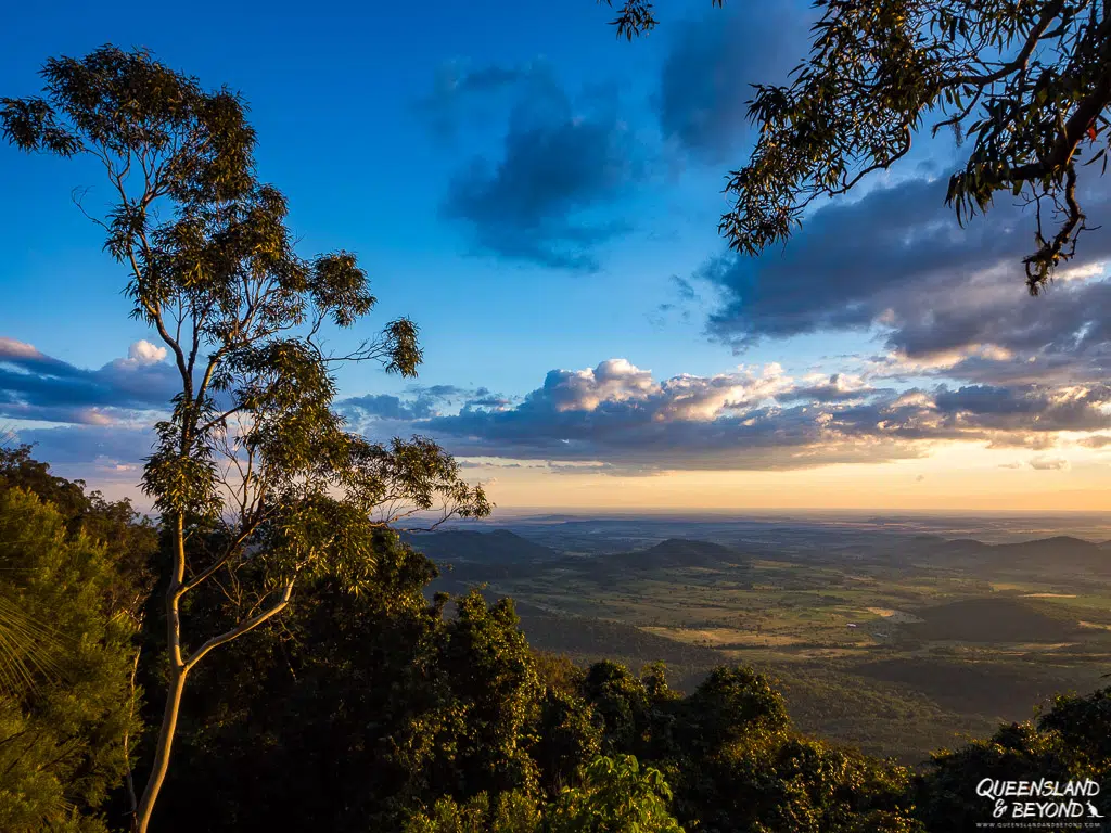
Doing the ridge tracks one by one will turn the Paradise to Westcott section into a 6.4km return hike that’s relatively flat and straightforward.
I think this is the least scenic section as you hike mostly through rainforest and open forest until you reach Westcliff Lookout. You’ll get nice sunsets from here though.
WESTCOTT TO CHERRY PLAIN
WESTCOTT TO CHERRY PLAIN TRACK AT A GLANCE
The next section from Westcott camping area to Cherry Plain has more exposed ridge walking but no formal lookout. It tends to be a little overgrown but also sees fewer crowds.

If you’re hiking this section, combine it with the short Koondaii Circuit, that way you’ll get to see different things on your return.
CHERRY PLAIN TO BURTONS WELL
CHERRY PLAIN TO BURTONS WELL TRACK AT A GLANCE
Of the three sections, I like the Cherry Plain to Burtons Well best. If you want to do it as a return walk, you’re looking at a solid half day walk (12km return).

We hiked it in reverse, starting at Burtons Well, and then returned via the road (2.4km). It’s much shorter but also very unexciting and in fact, seemed incredibly long and hilly at the end of the day.
This section offers the most lookouts and exposed ridge sections so if you only have time for one ridge walk, make it this track.

KOONDAII CIRCUIT
KOONDAII CIRCUIT AT A GLANCE
The shorter Koondaii Circuit is best integrated into the Westcott to Cherry Plain ridge track because you can easily complete the loop section on your return.

It’s only a short walk but you’ll head down the ridge and then climb back up again for a bit of heart-pumping exercise.
If you’re short on time for the whole ridge walk, just hike to Koondaii Lookout—it faces slightly differently and you’ll get some great views.
MOUNT KIANGAROW
MOUNT KIANGAROW TRACK AT A GLANCE
The Mount Kiangarow Track starts near Burtons Well, and takes you to its summit, which happens to be the highest mountain of the Bunya Mountains (1,135m).

The track is a gradual uphill and in itself not that exciting as you’ll hike through open forest. But you will get some nice valley vistas from the top of Mount Kiangarow and be surrounded by ancient grasstrees (which are just incredibly cool).
BEYOND THE WALKING TRAILS: WHAT ELSE TO DO AT THE BUNYA MOUNTAINS
If you’ve done enough hiking or just don’t feel like it, here are a couple of other ideas for what you could do at the Bunya Mountains.
SPOT A WALLABY, OR TWO OR THREE…
The Bunya Mountains are the perfect spot for being surrounded by gorgeous red-necked wallabies!
You’ll be greeted by them as you crawl out of your tent and attempt not to step into wallaby poo every metre. Or you can ogle at them as they eat and lounge about in the many open grass areas around Dandabah.


I’m sure if you rented a cottage or cabin, you’d find them happily munching the grass in your front yard. So, if you’ve never met one of these cuties, Bunya is where you should come.
WATCH THE SUNSET
The western side of the Bunya Mountains is nicely positioned for sunset watching. You’ll see the sun get swallowed up by the horizon over the farmland below, which is actually a whole lot nicer than it might sound.
You could head to Westcliff Lookout, Bottle Tree Bluff or Bunya Mountains Outlook just outside the national park—all provide great clear views.

Because Westcliff Lookout isn’t that far from Westcott camping area, expect to share that sunset moment with a few people though. You know, like 6-7 people… And make sure you grab a torch—the walk back to the car park or campground will be quite dark.
For a bit more solitude, Bottle Tree Bluff is a great alternative—we had it completely to ourselves. The rails at the lookout also make a handy makeshift stand if you forget your tripod.

Mount Kiangarow makes a decent backup spot too, complete with a bench if you want to sit back and watch the light fade.
VISIT A CAFÉ AT DANDABAH
You’ve got the choice of two café spots at Dandabah: Poppies on the Hill and The Bunyas. Both get packed on weekends.

We haven’t tried either but I am quite keen to try Poppies’ signature beef & bunya nut burger since they now offer gluten-free options! Bunya nuts, the seeds from a bunya cone, are mixed with beef into a burger patty—sounds intriguing, especially since bunya cones can weigh up to 8kg. Now that’s one heavy burger!
VISIT THE BUNYA MARKET
On the last Sunday of each month, you’ll find a fabulous community market held in Dandabah. Stalls sell anything from fresh eggs, sausages and cold meats, jams and chutneys, to clothes and artsy bric-a-brac.

The last time we were there, I bought so many delicious jars of jam and chutney, I’m afraid my pantry shelves will actually break.
EXPLORE RUSSELL PARK
If you want to escape the main national park crowds, head back down the road toward the Bunya Mountains Outlook (also known as Fisher’s Lookout) to explore Russell Park.
Managed by the local council, it offers some quieter walking tracks—including a track down to Cunjevoi Falls—along with picnic areas and purpose-built mountain bike loops if you’re keen on two wheels.
WRAPPING UP
Three nights at Bunya Mountains National Park is plenty of time to explore the trails, check out the lookouts and still have time for some relaxing in your camp chair.
It’s an easy, pleasant spot for a long weekend—even if it’s more of a “one–and–done” kind of spot rather than somewhere where you’ll want to head to every year.
Bunya Mountains Resources
Note: Check park alerts before heading out—track conditions can change and ticks are present year-round.
Happy exploring,

PIN FOR LATER



2 Comments
All Around Oz
8 December 2017 at 8:36 AMBunya Mountains has been on our ‘must visit’ list for awhile. Even more keen to do it now after reading your post.
Kati
8 December 2017 at 3:35 PMHey Melissa,
Thanks for stopping by! 🙂 Yep, it’s a nice little weekend escape if you’re in southeast Queensland. I reckon they’d be quite nice after a lot of rain (though possibly more ticks and mozzies too then), the waterfalls would just have a bit more water than what I saw. Hope you’ll meet lots of little furry friends when you make it there! 🙂