
These Sunshine Coast walks are on Kabi Kabi and Jinibara Country. I acknowledge the Kabi Kabi and the Jinibara peoples as the Traditional Custodians whose lands and waters we all now share on the Sunshine Coast. I pay my respects to their Elders past and present.
Although the Sunshine Coast Hinterland Great Walk isn’t a bad multi-day hike (we’ve done it multiple times), the Sunshine Coast really shines when it comes to shorter, quick walks. There are plenty of pleasant if not outright beautiful little gems.
Here are some of my favourite short Sunshine Coast walks.

FROM BEACHES TO RAINFORESTS
The Sunshine Coast is ecologically quite a diverse region.
From sandy beaches, sand dunes and coastal scrubland, rainforests, wetlands, dry eucalypt forest to rolling hills and volcanic outcrops. Except for mountains and desert, it’s all there.
And just as diverse as the landscape are the short walks you can find here.
This is a list of short and easy Sunshine Coast hikes, and by ‘short’ I mean hikes less than 5km, making most of these walks family-friendly.
Want more than 5km? If you’re after something a bit longer, check out my post on longer bush walks on the Sunshine Coast for when you want to spend a half-day or full day out on the trails.
I’ve split the walks into:
Whether you’re heading into the rainforest or along the beaches, there are a few things I generally have with me for a short walk.
Day Trip Essentials
NORTHERN SUNSHINE COAST WALKS (NOOSA TO COOLUM)
The northern end of the Sunshine Coast offers gorgeous walks along beaches and coves, to viewing platforms from where you can admire the sprawling coastline, and through dry forest, farmland and lakes.
1. MILL POINT CIRCUIT | COOLOOLA RECREATION AREA
Mill Point Circuit At a Glance
The Mill Point Circuit in Cooloola Recreation Reserve is only just over 5km but it’s also a very easy walk. There are a few other walks in the area so you could easily extend it if 5km is too short for you.


The track is entirely flat and takes you through bushy areas out to Lake Cootharaba at Mill Point.
You can still see a couple of historical remnants of a sawmill operation at Mill Point.
As you stand at the shore of the lake, it’s hard to imagine though that in the late 1800s, there used to be an entire complex of workshops, a school, hotel, store and houses here to support the Elanda Point sawmill.
2. NOOSA COASTAL TRACK (TO DOLPHIN POINT) | NOOSA NATIONAL PARK
Noosa Coastal Track At a Glance
The coastal track is possibly the most popular walk on the Sunshine Coast, and rightly so, it is a beautiful part of the coast.

Stunning coves, sandy beaches, turquoise water, and sprawling views along the coastline and into the Noosa hinterland. During migratory season, you might have the chance to see dolphins or even whales.
If Dolphin Point (2.4km return) isn’t far enough for you, or it’s simply too beautiful, keep going to Hell’s Gates (2.7km one-way from the day-use area). Here you’ll get views up and down the coast, and down into the swirling waters of Hell’s Gates.
Ideally, go during the week. Weekends can be very crowded, especially around Tea Tree Bay and Winch Cove.
Keen to brave the crowds? If you’re prepared to fight for a carpark (on the weekends), I’ve written a more detailed guide to the Noosa Coastal Track that covers the different sections in case Dolphin Point isn’t quite far enough for you.
3. EMU MOUNTAIN | NOOSA NATIONAL PARK
Emu Mountain At a Glance
Apart from the section at Noosa headlands, Noosa National Park has another three sections, one of which is the Emu Mountain section.
Emu Mountain is, however, right next to big brother Mount Coolum and just outside Coolum Beach. Not around Noosa as such.

It’s usually fairly quiet, and thus unlikely that you’ll have to contend with any crowds.
It’s not very high or long but you’ll get fabulous 360° views along the coast and especially towards Mount Coolum.
You could turn this walk into a slightly longer loop by returning along the alternative trail, which then joins with the Hakea track.
You’ll end up at a different entrance to the park but just walk along Havana Road East to get back to where you started.
It’s not a very big area, you won’t get lost.
4. MOUNT COOLUM SUMMIT | MOUNT COOLUM NATIONAL PARK
Mount Coolum Summit At a Glance
Don’t expect to be on your own here, Mount Coolum’s many steps are very popular for exercise nuts and families alike.

The track is entirely uphill with plenty of steps thrown in.
Even if you’re slow and need to take lots of breaks climbing up to the summit, it probably won’t take more than 30-45 minutes going up.
The views from the top are splendid, especially now that more viewing spots have been created.
If you’re keen on clear views, winter is best as there won’t be as much moisture in the air. Sometimes you can almost glimpse Caloundra in the far distance.
The carpark at Tanah Street West isn’t huge but you can park along the road if you can’t find a spot in the actual carpark.
5. MOUNT NINDERRY | NINDERRY
Mount Ninderry At a Glance
The Mount Ninderry Track is nowhere near as popular as the Mount Coolum climb or the Noosa Coastal Track. You’ll generally find more local people here, taking their dogs for a walk as Mount Ninderry isn’t in a national park and pets are allowed.

It’s a little uphill initially but nothing like Mount Coolum so quite suitable for various fitness levels.
There’s a formal viewing platform towards Mount Coolum and the coastline.
As you trace your way back, follow the track towards the other side of Mount Ninderry for some views into the hinterland. You can get some nice sunsets here.
Just be aware that the carpark is ridiculously tiny. There’s really only space for 2-3 cars so you may need to squeeze in along the road.
CENTRAL SUNSHINE COAST WALKS (MAROOCHYDORE TO CALOUNDRA)
The suburbs around Maroochydore, Mooloolaba and all the way south to Caloundra are fairly built up now.
Apart from some coastal walks, there are also some wonderful gems in little pockets of rainforest, dry eucalypt forest or around lakes.
6. BUDERIM FOREST WALK | BUDERIM
Buderim Forest Walk At a Glance
The Buderim Forest Walk to Serenity Falls is a gorgeous little pocket of rainforest in the middle of the suburb of Buderim. It seems hidden but it’s well known, and especially popular in summer when people go for a quick dip in the rock pool.


You can start the walk from either end. I really enjoy the boardwalk section from the Harry’s Lane end but only because I’m a boardwalk fan.
I love winter here but only because there are far fewer mozzies around and it’s not quite as humid. On the flip side, Serenity Falls won’t be flowing quite as dramatically as they do after a good rainfall in summer.
Keen for more rainforest? If you want to see where else is worth a look after a good downpour, I’ve got a post on the best waterfalls on the Sunshine Coast—mozzies and all.
7. BUDERIM PALMWOODS HERITAGE TRAMWAY | BUDERIM
Buderim Palmwoods Heritage Tramway At a Glance
The walk along the former Buderim Palmwoods tramline is only a short little trail, tracing the historic train connection between Buderim and Palmwoods. But it’s a good alternative for sunny days as it’s very shady.


Unfortunately, there isn’t much to see anymore. There are no views as such but you can find some remnants of some old train sleepers and sections where a path must have been hewn through rocks.
The trail is slightly downhill, and while you may not notice that going down, you will coming back.
There are interpretative panels at the start of the track but you can also read more about the history of the Buderim-Palmwoods tramway here.
8. SUNSHINE COAST COASTAL PATHWAY | COTTON TREE TO MOOLOOLABA
Sunshine Coast Coastal Pathway At a Glance
The Sunshine Coast Coastal Pathway cover 73km, from Tewantin in the north all the way to Pelican Waters in the south (with a few sections that don’t connect easily).

One of the most popular stretches is Cotton Tree to Mooloolaba given the gorgeous coastal views (and the many cafes, no doubt).
I really like walking from Cotton Tree to Alex, and then up and over the hill to Mooloolaba as that entails a little more exercise and some fantastic views of the coastline as you come back.
It’s almost 5km from Cotton Tree to Mooloolaba but as I said, you can start anywhere you like and make it as short or long a walk as you want to. You could, for example, just walk from Alex to Mooloolaba and return via the beach / rock pools if it’s low tide.
That’s a pretty nice walk!
9. NATURE WALK | POINT CARTWRIGHT RESERVE / LA BALSA PARK
Point Cartwright At a Glance
La Balsa Park (harbour side) and Point Cartwright Reserve is a lovely, though busy, spot for a stroll.


There are walking tracks all around the park, up to the lighthouse at the tip and the muralled water reservoir. Up here, you might be lucky enough to spot some whales during migratory season.
From the Point Cartwright Lighthouse, you can stroll along the beach and out to the entrance of the spit.
It’s a popular spot for families, dog walkers and sunset watchers. Enjoy the views across to Mooloolaba and up the coast to Mount Coolum and beyond.
Fun fact: The park is named after a raft expedition (‘La Balsa’) that arrived from Ecuador in the 1970s!
10. BORONIA TRACK | MOOLOOLAH RIVER NATIONAL PARK
Boronia Track At a Glance
The Boronia Track at Mooloolah River National Park happens to be one of my favourite hikes on the Sunshine Coast, mostly because you don’t tend to meet very many people.


The walk takes you through some beautiful shrub and coastal heathland. It’s especially pretty in spring.
Avoid summer or when there’s been heavy rain as some of the tracks can get very muddy. It’s also very exposed, another reason to avoid doing the track in summer unless you go early or late in the afternoon.
We usually turn the Boronia Track into a loop via the Aemula and Littoralis Trails, and that ends up being about 7km.
The only downside to this walk is that you can hear highway noise along some stretches of it, making it a bit less peaceful than I’d wish.
11. CURRIMUNDI LAKE | CURRIMUNDI
Currimundi Lake At a Glance
The loop around Currimundi Lake is more of a suburban stroll but it’s still a really nice one.

You can start from anywhere on this loop. Either park at Crummunda Park or along Coongarra Esplanade on the northern side of the lake. On the southern end, Westaway Parade has some parking spots.
The track on the northern side of the lake has a great viewing platform. The track then takes you through some coastal heathland in Currimundi Lake Conservation Park before ending at the mouth of the lake on the ocean side.
The lake crossing at the mouth changes all the time. I’ve had to take my shoes off and find a spot to wade through the water but when the tide is low, you can just walk across.
If it’s too wide or woolly, you may have to return the same way.
12. SUNSHINE COAST COASTAL PATHWAY | CALOUNDRA
Sunshine Coast Coastal Pathway At a Glance
As mentioned above, you can walk almost the entire coastline of the Sunshine Coast, there are so many sections of the Coastal Pathway.

If you’re at the southern end of the Sunshine Coast, the stretch around Caloundra makes for a beautiful, family-friendly walk.
The entire Caloundra section is actually 9km but just walking from Bulcock Beach to Moffat Head is a great walk. Like with the Mooloolaba to Cotton Tree stretch, you can make this as long or short a walk as you want to.
On the way back, you’ll be able to spot some Glass House Mountains in the far distance as you come around Wickham Point (Caloundra Head) and walk towards Happy Valley.
13. COSTIGAN MANGROVE BOARDWALK | GOLDEN BEACH
Costigan Mangrove Boardwalk At a Glance
The Costigan Mangrove Boardwalk at Golden Beach is a really short section along the Coastal Pathway.


The beauty of it is that it takes you through a lovely slice of a delicate mangrove ecosystem harbouring six species of mangroves. Mangroves can be a bit stinky but this isn’t a big mangrove system so it’s fairly contained. 🙂
There are quite a few interpretive signs along the boardwalk if you’re keen to learn more about mangroves.
You also get some views of Pumicestone Passage and Bribie Island, and of course, the mangrove flats, especially at low tide.
You might want to explore this boardwalk as part of a longer stroll along the Coastal Pathway in Golden Beach or Caloundra.
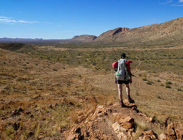
SUNSHINE COAST HINTERLAND WALKS
Pretty much all the hikes, short or long, in the Sunshine Coast hinterland are rainforest walks.
Mozzies can be a bit of a pest (as can leeches) but you’ll also be spoilt with some beautiful rainforest, piccabeen palms, waterfalls and valley views.
14. WOMPOO CIRCUIT | MAPLETON FALLS NATIONAL PARK
Wompoo Circuit At a Glance
The Wompoo Circuit in Mapleton Falls National Park is one of my favourite short rainforest walks in the hinterland.


The rainforest here is full of tall piccabeen palms with some fine specimens of giant strangler figs mixed in.
It can be hot and humid in summer but it’s still generally a pleasant walk as it’s mostly covered, except for some short sections through dry eucalypt forest.
We usually combine this walk with the 50m detour to Mapleton Falls Lookout. The falls are hard to see from the lookout though, it’s much easier viewing them from the trail. In winter, there’s usually only a trickle of water.
In any case, the views into Obi Obi Valley from the lookout are quite pleasant and expansive.
15. KONDALILLA FALLS CIRCUIT | KONDALILLA NATIONAL PARK
Kondalilla Falls Circuit At a Glance
Though not quite as crazy popular as Noosa National Park, it can be quite the challenge trying to get a carpark at Kondalilla Falls in the Blackall Ranges. Come early in the morning if you want to avoid (most of) the crowds.


The hike starts at a lovely picnic area with barbeques.
From there it’s a relatively short walk to a popular swimming hole, so bring your swimmers if you’re here in summer.


The Kondalilla Falls Circuit then takes you to the base of the falls and past a couple of lookouts on the way up.
Keep in mind that there are some 300 steps as part of the loop (and also some steps to get to the rock pool) so you’ll need some level of fitness to a) go down all those stairs and then b) get back up again.
You’re in rainforest country here so the walk is pretty shady and it’s a good option for a warmer day as you’re not exposed the entire time. It can get humid though with plenty of mozzies buzzing about!
Not done with the hinterland? If you don’t mind the humidity, I’ve put together a list of other spots worth visiting in the Blackall Ranges, including a few more lookouts, picnic spots and rainforest tracks.
16. BAROON LOOKOUT | KONDALILLA NATIONAL PARK
Baroon Lookout At a Glance
The short walk to Baroon Lookout walk is the start of the Sunshine Coast Hinterland Great Walk. It’s a really pleasant walk to a couple of lookouts.

The first lookout is over the Narrows Gorge (2.2km return). You could just do this one if you’re short on time or energy.
From the second lookout, you can see Baroon Pocket Dam in the distance and also get some views into Obi Obi Gorge.
This walk connects to the Kondalilla Falls Circuit as part of the Sunshine Coast Hinterland Great Walk. So if you want a longer hike, you could just keep going.
From Baroon Pocket Dam to Kondalilla Falls, it’s about 10km one-way.
Want more views? If you’re looking for more spots to view sunrise or sunset, check out my Sunshine Coast Lookouts guide.
17. RAINFOREST WALK | MARY CAIRNCROSS SCENIC RESERVE
Mary Cairncross Rainforest Walk At a Glance
The Rainforest Walk at Mary Cairncross Scenic Reserve is gorgeous. It’s a beautiful example of what healthy rainforest looks like on the Sunshine Coast.
It’s a relatively flat walk, and the reserve is a great place to bring friends and family for a picnic.


My favourite part of the Rainforest Walk is the boardwalk through the strands of piccabeen palms, they’re so tall and skinny, and just beautiful.
There’s an interactive interpretative centre (great for kids) and a café that serves pretty nice food (including gluten-free options).
It’s generally quite busy around here, not surprising when there’s a park with barbeques and a playground as well as great views of the Glass House Mountains.
Please be aware that this walk is only open 7am to 6pm daily.
18. TUNNEL TRACK | DULARCHA NATIONAL PARK
Tunnel Track At a Glance
The Tunnel Track is another historic Sunshine Coast walk, and one that’s not too overrun. You’ll be able to enjoy some peace and quiet here, provided that not too many motorbikes are cruising around the nearby state forest.

The tunnel was once part of the Brisbane-Gympie rail connection, and opened in 1891. All that remains of the track now is the tunnel.
From the carpark at the Mooloolah end (northern entrance) to the actual rail tunnel, it’s only 900m so you could just walk to the tunnel, walk through it for a bit of fun and then turn around.
To do the whole track from the northern to the southern entrance, it’s 3km each way but it’s fairly flat and won’t be very strenuous at all.
The trail is a shared trail, and we generally see more mountain bikers than walkers around here.
19. WILD HORSE MOUNTAIN LOOKOUT | COOCHIN CREEK
Wild Horse Mountain Lookout At a Glance
The Wild Horse Mountain Lookout Track is along a paved access road. It’s uphill all the way, and though semi-shaded and short, can be strenuous if you’re doing it in hot weather.

The lookout platform is covered so you’ll at least enjoy some shade as you take in the panoramic 360° views.
The lookout is best enjoyed in the winter months since the views will be much clearer. Sometimes you can see as far as Brisbane.
20. TIBROGARGAN CIRCUIT | GLASS HOUSE MOUNTAINS NATIONAL PARK
Tibrogargan Circuit At a Glance
There are a few walks in the Glass House Mountains, some more interesting than others.
Most of them involve a climb to the summit (e.g. Beerwah), and every year some unprepared hikers invariably get stranded and have to be rescued. (There are also calls to close some of these summit climbs for cultural reasons.)

For a relatively flat and easy hike, try the Tibrogargan Circuit, which, as the name suggests, circumnavigates the base of Mount Tibrogargan.
The walk is partly shaded and through dry forest so shouldn’t be as exposed as a beach walk or as humid as a rainforest walk.
You’ll also get glimpses of Mount Tibrogargan and some of the other Glass House Mountains from Mountain Lookout. Along the way, you can enjoy some intermittent views into the surrounding farmland and state forest plantations.
If you’re after a slightly longer walk, you can easily combine the Tibrogargan Circuit with the Trachyte Circuit (5.7km), which starts from the same trailhead.
Done with the walking for today? If your legs need a break, you can see the Glass House Mountains from your car instead. I’ve mapped out a Glass House Mountains scenic drive that hits all the lookouts without doing a massive climb.
21. FIG TREE WALK | IMBIL STATE FOREST
Fig Tree Walk At a Glance
If you’re happy to venture further inland, there’s a very quick circuit through some lovely rainforest just 6km outside of Kenilworth in the hinterland.


It won’t take long at all do the Fig Tree Walk where you can admire both piccabeen palms and strangler figs. Some of the stranglers are incredibly huge and you can almost hide in their buttresses.
Just be careful not to touch leaves around here as there are some stinging nettles that can give you a nasty rash and itchy skin (but nothing much more serious than that).
ENOUGH TO KEEP YOU BUSY?
This is just my list of favourite short walks on the Sunshine Coast so, obviously, it’s not exhaustive.
I also really like some stretches of the Coastal Pathway around Coolum (the boardwalk going out to Point Perry) and Golden Beach.
I could have added the Linda Garrett Circuit near Mapleton, which is a nice enough walk but there are other, more stunning rainforest walks in the Sunshine Coast hinterland.
But if you think I’ve forgotten some special quick hike, let me know in the comments below. I’ll be very happy to check it out.
Happy walking,

SAVE TO PINTEREST


7 Comments
Gavin Harm
9 October 2020 at 5:49 AMIts good to get a comprehensive list of walks but it lacks two things about each walk…1. The length/ave’ time and 2. The degree of difficulty for each walk.
Kati
22 October 2020 at 12:24 PMHi Gavin,
Thanks for your comment but I have actually included the information you found lacking. 🙂 It’s in the ‘basic trail info’ for each walk. I’ve included the distance (= length) and the difficulty (e.g. easy, moderate, etc.) here. What I haven’t included is the average time, you’re right, because I find that everybody walks at a different pace and it really differs if you have small children along etc.
Karen
18 November 2020 at 9:53 PMAll of your location posts are very informative with a good range of visuals – thank you for the detailed accounts and tips – very handy when planning my own adventures.
Kati
1 December 2020 at 12:52 PMHi Karen,
Thanks for your positive comment, much appreciated! 🙂 Enjoy your walking/hiking adventures on the coast, there are so many places to explore (and so many I haven’t included yet!).
Hilary
28 March 2023 at 1:46 PMHi Kati – we love visiting the Sunshine Coast from NZ and doing the beautiful walks. Your lists are far more informative than many of the official maps and websites I’ve found – thank you!
But you don’t mention my favourite Aussie walking activity – looking for pademelons in the Mary Cairncross Scenic Reserve!! We always find some and they are adorable! (we don’t have them here in NZ!)
Kati
28 March 2023 at 7:25 PMHi Hilary,
Oh, what a lovely comment, thank you so much! We love visiting NZ (and in fact, we’ll be doing the Milford track (finally!!, thanks pandemic!) soon). We love NZ because it’s nice and cool, and so different from here. Hiking in NZ is ridiculously relaxing… 😀 no crazy critters to look out for on the trail. 🙂
And yes, you’re totally right about the pademelons at Mary Cairncross!! I love seeing them, they are so cute, I agree. 😍
mark
10 May 2026 at 11:28 AMHi Kati, just one thing with these walks would be good to know if you can take dogs as what I’m finding is you have to drive there then find the sign out front that will suggest dogs or no dogs, I know most if not all National parks don’t allow dogs, but if you look at walk no 18 tunnel Track Dularcha National Park well it does suggest National park, first I’d think no dogs but if you read in the notes it suggest you’ll see more motor bikes than walkers coming form the state parks, I would have also though with a notional park that no motor bikes would be allowed on these tracks? which tends to lead me to, that dogs are probably allowed on this track?