
This post contains affiliate links. If you buy something through these links, I may earn a small commission at no extra cost to you. I only recommend gear I’ve actually used out on the trails and really loved! Read my full disclaimer.
Springbrook National Park is on Yugambeh Country. I acknowledge the Traditional Custodians of this area and their connection to Country, and pay my respects to their Elders past and present.
If you aren’t blessed with a lot of time, Springbrook National Park is a solid option for a day of chasing waterfalls without having to trek into the middle of nowhere.
It’s compact and close enough to the Gold Coast or Brisbane that you don’t need to pack an overnight bag. (I’ve actually written some reflections on how this area stacks up against the Sunshine Coast—the hinterland national parks win every time!).
Most of the waterfalls are conveniently easy to get to, which is great, except for the part where everyone else had the same idea.
If you’re heading up here, bring the right attitude—and maybe a bit of patience for the “influencer” traffic. 😉

We first visited many years ago while on holiday from Melbourne. It was probably quieter back then, or maybe I’ve just become more aware of the crowds. We did a couple of lookouts and walked to some water, but I honestly didn’t remember much of it.
But I’ve paid attention since then! 🙂
SPRINGBROOK: WHAT TO KNOW BEFORE YOU GO

SPRINGBROOK SECTIONS: DON’T END UP IN THE WRONG VALLEY
Springbrook National Park is split into four sections. They look close on a map, but the geography is basically designed to make you drive in circles if you don’t pick the right turn-off.
- The Springbrook Plateau: This is the main spot where most of the waterfalls (and people) are.
- Natural Bridge: Famous for the rock arch and glow worms. It’s in the Numinbah Valley, below the plateau (along the Nerang-Murwillumbah Road).
- Mount Cougal: Tucked away in the Currumbin Valley. You can see the plateau from here, but you can’t get to it without a massive detour.
- Numinbah: Mostly for the scenery; there aren’t any formal walking trails here.
GETTING TO SPRINGBROOK
Basically, you need a car.
There’s no public transport, and unless you’re an elite cyclist with a death wish, you aren’t riding up. It’s about 50km from the Gold Coast and 100km from Brisbane.
GETTING AROUND
If you’re visiting from interstate and flying into Brisbane or Coolangatta, comparing local car rates early is a must.
🚙 CAR HIRE: I’d suggest you compare rates on DiscoverCars because they aggregate the local providers at Gold Coast Airport and Brisbane Airport so you don’t have to check ten different sites yourself.
THE ROADS
For years, there’ve been road closures from 2017, but as of 2026, the Gold Coast-Springbrook Road is finally seeing some major reconstruction. Expect roadworks and “stop/slow” signs if you’re coming up from Mudgeeraba.
If you prefer a slightly less “under construction” vibe, take the Nerang-Murwillumbah Road and wind your way up via Pine Creek Road. It’s picturesque, sealed and fine for a normal car, though it’s still steep and narrow enough to keep you awake.
THE MOUNT COUGAL TRAP
If you want to visit Mount Cougal after the plateau, it’s an 80km journey.
You either have to head all the way back to the Pacific Motorway or take the long, scenic route through New South Wales and back into Queensland. It’s a nice drive, but it’s a lot of time behind the wheel just to see another creek.

CAR PARKING: THE GOLD COAST’S HUNGER GAMES
I mentioned the crowds, but the parking is the real bottleneck.
- Canyon Lookout & Purling Brook: These are the worst for congestion. There is a “site upgrade” project currently underway to add more spots, but until that’s finished, the parking overflow spills onto residential streets.
- The Tallanbana Toilets: Just a heads-up—the toilets at the Tallanbana trailhead (Twin Falls) have been closed for a while. Your best bet is to stop at the Visitor Centre or the Goomoolahra picnic area before you start your walk.
WHEN TO VISIT
Springbrook is open year-round, but your experience depends entirely on your tolerance for humidity and leeches.
- Summer (Dec-Feb): This is peak waterfall season. The rain is heavy, the falls are spectacular, and the air is lush. It’s also 100% humidity and the leeches are out in force. If you don’t mind getting wet (and potentially being fed upon), this is when the park looks its lushest.
- Autumn (Mar-May): This season is my favourite. You get mild temperatures, relatively clear tracks, and enough lingering rain to keep the falls flowing without the oppressive summer heat or extreme humidity.
- Winter (June-Aug): If you want clear views of the coast, come in winter. It’s crisp, dry, and actually quite cold on the plateau—temperatures can drop below 0°C overnight. The waterfalls might be more of a trickle, but you won’t sweat through your shirt.
- Spring (Sep-Nov): Honestly, the park’s driest look. Unless the wet season starts early, the waterfalls become non-existent and the rock pools get a bit stagnant. It’s not as humid yet but don’t expect “Jurassic lushness”.
STAYING DRY & LEECH-FREE
WHERE TO CAMP (OR NOT) AT SPRINGBROOK
If you’re planning on staying more than a day, your options on the plateau are surprisingly limited. It’s a spectacular park, which is why it’s also in my favourite weekend camping spots.
THE SETTLEMENT CAMPING AREA
This is the only official camping spot on the plateau. It’s essentially a small area with 11 defined sites. It’s very convenient for a night or two, but it’s not exactly “wild” camping.
- The setup: Good for tents, camper trailers and small campervans, but leave the caravan at home—it won’t fit and turning around will be a nightmare.
- Facilities: Toilets, non-potable drinking water, and electric BBQs. No showers and no fires.
- Booking: Essential through the QNP site. Don’t just rock up and hope for the best; the rangers actually check.
Plan your stay: For a more detailed look at the site layout and what to expect, I’ve put together a Quick Guide to Springbrook National Park Camping.
OTHER OPTIONS
If The Settlement is full or you want more space, look into Hipcamp listings or private campgrounds down in the Numinbah Valley. You’ll be at the base of the mountain, which is usually a few degrees warmer in winter. Otherwise, there are plenty of B&B options if you prefer a real bed and a shower.
CHASING WATERFALLS: SPRINGBROOK IN A NUTSHELL
Springbrook is part of the Gondwana Rainforests of Australia, an ancient World Heritage area straddling the QLD/NSW border.

We’ve hiked in quite a few of these parks, and the scenery here is spectacular—provided you can actually see through the mist and clouds.
Aside from the Warrie Circuit (17km) and the Gold Coast Hinterland Great Walk, most trails here are surprisingly short. You could technically cram the highlights into a single day if you’re fit and the weather isn’t melting you.
That said, “short” doesn’t mean “flat.” There are plenty of stairs involved.
If your knees are as questionable as the husband’s, you’ll probably want to space these out over two days. You’re better off slowing down anyway—it’s hard to appreciate a 2,000-year-old Antarctic Beech tree if you’re power-walking to beat the traffic.
CANYON LOOKOUT & TWIN FALLS CIRCUIT
This area is the heart of the plateau. It’s where you get the most “wow” for the least amount of effort, which naturally means it’s where you’ll find the most people.
THE FIVE-METER VIEW: CANYON LOOKOUT

If you’re short on time or your knees have reached their limit, Canyon Lookout is about as easy as it gets.
It’s located just off Springbrook Road, and if you’re lucky enough to score one of the few parking spots, you only have to walk about five meters to see the view.
From the rim, you can see Twin Falls and Rainbow Falls plunging over the edge of the plateau. It’s a spectacular view, even if you don’t break a sweat to see it.
THE FULL WALK: TWIN FALLS CIRCUIT
Twin Falls At a Glance
Note (2026): The Tallanbana toilets are still closed; head back to Goomoolahra or the Info Centre before you start.
If you actually want to see the falls properly, you need to go down to the lush rainforest. The path starts on the plateau and winds its way through ancient palms and tree ferns to the base of the cliffs.

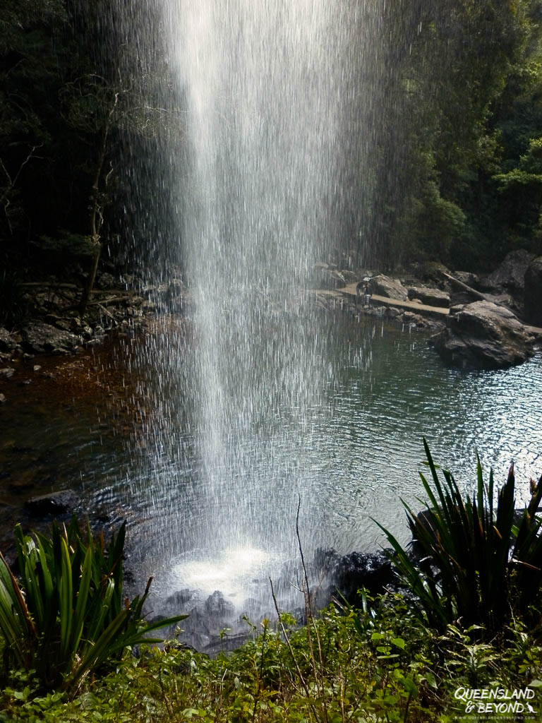
- Walk behind the water: The highlight of this circuit is that you can walk directly behind the falls. In the height of summer or after a decent rain, expect to get “a bit of spray” on you. It’s a great way to cool down, but less great for your camera gear.
- The climb: Like most walks here, what goes down must come up. It’s a steady climb back to the top, but the track is well-maintained.
- The crowd factor: We first did this mid-week in August many years ago and had it mostly to ourselves. These days, those quiet moments are rare. If you want to avoid feeling like you’re in a themed queue, get here early and avoid weekends.
Taking it Further: If 4km feels like a warm-up, the Warrie Circuit (17km) branches off from here. It adds another seven or so waterfalls to your day, but it’s a much bigger commitment.
PURLING BROOK FALLS & WARRINGA POOL

Purling Brook is the poster child of Springbrook.
It’s a 100m plunge that looks incredible after rain, but it’s also the place where you’re most likely to be stuck behind a tour group or a family in thongs.
THE VIEW FROM THE TOP: PURLING BROOK LOOKOUTS

If you aren’t up for the climb, you can still see the main falls.
There are two lookouts near the top of the falls—one on either side of the gorge. They are a short, relatively flat walk from either the Gwongorella or Settlement parking areas. You get a direct look at the falls cascading over the edge, and on a clear day, you can see right down into the valley.
THE FULL LOOP: PURLING BROOK CIRCUIT
Purling Brook Falls At a Glance
Strategy: Walk clockwise to tackle the stairs on the way down and save your knees the trouble on the way back up.
This trail takes you from the plateau rim down to the very base of the falls and back up again.

- The strategy: Unless you have a strange passion for climbing endless stairs, do the hike clockwise. It’s still a steep walk down through the shady (i.e. humid) rainforest, but the switchbacks on the return leg are much kinder to the knees.
- The crowd factor: This is a very popular walk. Be prepared to wait for people to pass on narrow sections. If you want to avoid the “human traffic jam” feel, come mid-week or early in the morning, and avoid summer.
- The suspension bridge: This is the highlight of the base. Crossing the bridge gives you the best perspective of the sheer rock walls and the scale of the falls tumbling down.


The good news is that the full loop is open again.
For a long time, landslides meant you had to turn back at the bridge and climb the stairs you just came down—now you can complete the circuit and walk the easier uphill path on the other side.
THE EXTENSION: WARRINGA POOL
Warringa Pool At a Glance
Note: This is a detour from the main circuit. It’s a great spot for a swim, but remember you still have the climb back to the plateau afterward.
If you’ve made it all the way to the base of the falls, it’s worth adding the 2km return detour to Warringa Pool.

The track follows Little Nerang Creek to a large, deep rock pool.
It’s a great spot to jump in and cool off, though as the husband discovered, that “cool” feeling lasts exactly five minutes in summer until you start the humid climb back up to the plateau.
If you’re chasing waterfalls, the Binna Burra side of Lamington National Park has some of the best in the region, including impressive Coomera Falls.
ROADSIDE STOPS: THE BEST (AND NOT-SO-BEST) PLATEAU LOOKOUTS
If you’ve finished the big circuits or your knees are officially on strike, the plateau has several “low effort, high reward” stops. Most are just a few hundred meters from your car.
WUNBURRA LOOKOUT: THE “JUST ARRIVED” VIEW
This is the first lookout you’ll hit as you climb the plateau on Pine Creek Road. It’s actually just before you enter the National Park proper.
- The view: You get a decent look into the Purling Brook Valley and down to Little Nerang Dam.
- The verdict: To be honest, I wasn’t that impressed. I don’t even have a photo of the actual lookout, though I did find a nearby sign interesting enough to photograph. 😆

- Parking: There’s only a small carpark here. If it’s a weekend and it’s full, don’t stress—just keep driving to the better spots.
BEST OF ALL LOOKOUT: BOLD CLAIMS AND ANCIENT TREES
Best of All Lookout At a Glance
Strategy: This is the highest point on the plateau; it is often 5°C cooler and far cloudier than the canyon area. Bring a layer even if it’s warm at the bottom.
Queensland loves to exaggerate a bit. There are so many best of in Queensland, it becomes quite hilarious.
Calling a view “Best of All” is about as bold as it gets. Is it actually the best? Maybe not, but it’s definitely worth the 600m return walk.
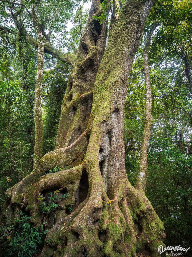
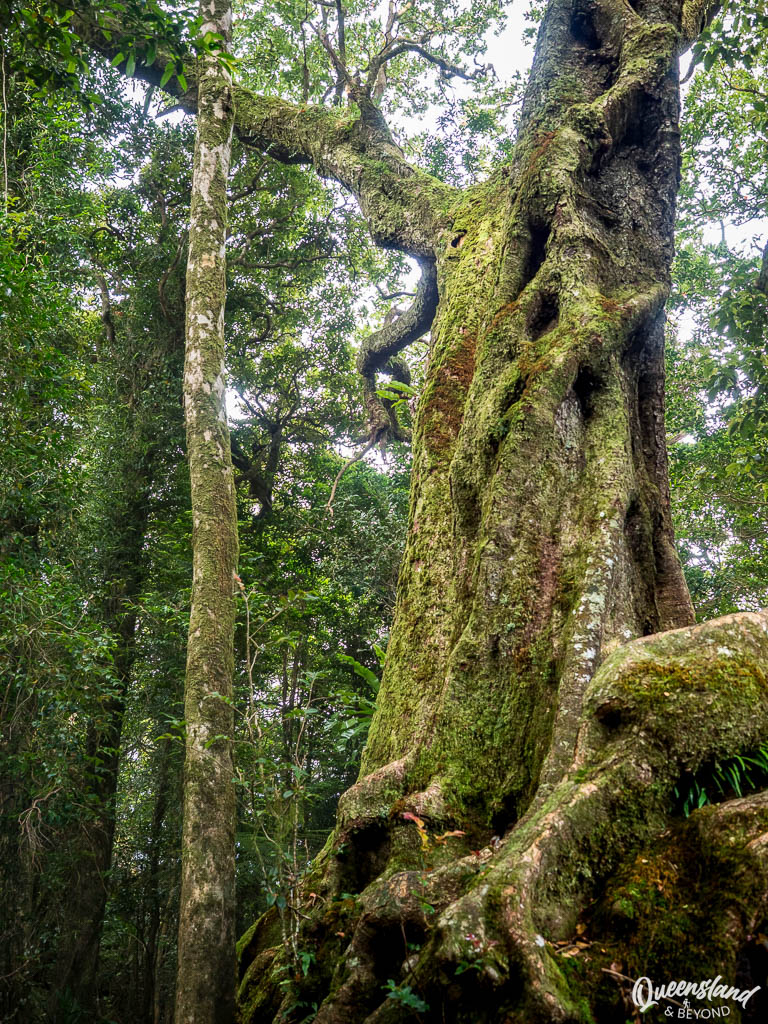
- The walk: The path takes you through a beautiful pocket of ancient Antarctic beech trees. These are thousands of years old and look properly prehistoric.
- The view: On a clear day, you get a massive panorama of northern NSW, the Scenic Rim, and Mount Warning (Wollumbin) looming in the distance.

- Parking: Follow Repeater Station Road to the end. There’s a giant carpark and an even bigger radio tower, so finding a spot is usually easy even on busy days.
If you’re here for the ancient Antarctic Beeches, Lamington National Park has even more expansive groves to explore and a much more rugged feel than the Springbrook plateau.
GAURIEMABAH: THE “PLACE OF STORIES” (AND GOLD COAST VIEWS)
This is the spot at the Information Centre (the old schoolhouse on Old School Road). Back when we first visited, this was just an unnamed boardwalk, but it’s now officially called Gauriemabah.
- The boardwalk: It’s a very short (100m) walk called the Buliya-Buliya Jagun Boardwalk.
- The view: This is probably the best place on the plateau to see the Gold Coast skyline. The views aren’t amazing but on a clear day, you can see the skyscrapers of Surfers Paradise.

GOOMOOLAHRA FALLS: PICNICS AND BOOJERAHLA TRACK
This is at the very end of Springbrook Road. It’s a great spot to wrap up your plateau tour because it’s shady, quiet, and has decent picnic facilities.


- The original lookout: It’s still only a 100m stroll to see the top of the 60m falls.
- The “new” track: There is now an additional short walk (about 450m return) called Boojerahla with expansive views.
- My Tip: Come early. Once the sun moves, the valley falls into deep shadow. If you visit in winter when the air is dry, you can apparently see all the way to Moreton Island. In summer? You’ll be lucky to see through the humidity haze.
NATURAL BRIDGE & THE GLOW WORM CAVE

To see the Natural Bridge, you have to leave the Springbrook plateau and head down into the Numinbah Valley. It’s about a 30-minute drive from the top of the mountain, so don’t expect to just “pop over” quickly.
THE WATERFALL AND THE ARCHED CAVE
Natural Bridge At a Glance
Note: There is no fuel in the Numinbah Valley; check your tank before leaving the Gold Coast or the Plateau.
The walk is a fairly easy, sealed loop that winds down to Cave Creek. While it’s short, it’s best done clockwise to get the best reveal of the bridge itself.
- The bridge: The highlight is the arched cave where the creek plunges through a hole in the roof, creating a stunning waterfall curtain.
- The cave interior: When we were there last around 6pm in summer, it was already dark enough to see the blue-green lights of the glow worms starting to emerge.
SEEING THE GLOW WORMS (WITHOUT KILLING THEM)
Glow worms are actually the larvae of a fungus gnat (not technically worms!), and that bioluminescent light is a sneaky way to lure in prey. To keep them glowing, there are a few “unbreakable” rules:

- No light: Do not shine torches or phone lights directly at the glow worms. They will literally “switch off” as a defense mechanism.
- No flash: Taking photos with a flash is useless for the photo and harmful to the ecosystem.
- Stay on the path: The entire creek area is strictly off-limits for swimming to protect the fragile larvae. If you want to cool off, head to nearby Bochow Park.
WHAT TO EXPECT AT NIGHT
Expect it to be busy.
After sunset, the cave fills up with people waiting for the “light show.” You’ll also likely see (and hear) small bats darting in and out of the cave. They won’t bother you, but if you aren’t a fan of things fluttering past your ears in the dark, stick to a daytime visit.
Bring a torch (or your phone) so you can find the way back to your car.
STILL ON THE TO-HIKE LIST
Even with multiple trips to the plateau, there are still corners of Springbrook I haven’t personally scouted yet. If you have extra days or a higher step-count goal than I did on my last visit, these are the two big ones remaining on my list.
THE ONE THAT GOT AWAY: WARRIE CIRCUIT (17KM)
Warrie Circuit At a Glance
If you are a serious hiker and 4km feels like a stroll, the Warrie Circuit is the “Big One” at Springbrook.
It’s currently on my “next time” list (my body wasn’t quite up for a 17km trek on our last trip), but it’s essentially an extension of the Twin Falls Circuit. It takes you deeper into the canyon gorge, past about seven more waterfalls, and through some of the most remote rainforest in the park.
If you tackle it, allow a full day (5–6 hours) and pack plenty of water. I’ll update this guide once I’ve finally ticked it off!
THE MOUNT COUGAL SECTION
This is a separate pocket of the park located at the end of Currumbin Valley Road, rather than up on the main plateau. I haven’t made it out here yet, but the 1.6km return Cascades track is high on the list. It’s a short, easy walk that offers scenic cascades and a look at an old 1940s sawmill.
SO, IS SPRINGBROOK WORTH IT?
Yep, of course!
Whether you’re there for the five-meter stroll to a lookout or the humid slog on a waterfall circuit, Springbrook National Park is essentially the Gold Coast’s most accessible slice of wilderness.
It packs everything: from whitewashed cliffs, tumbling waterfalls, rock pools, ancient Antarctic beech trees, and enough Gondwana rainforest to make you feel like a dinosaur might actually walk around the next corner.
You’ll also likely share the trail with a fair bit of wildlife—from a gazillion birds to goannas, pademelons and the very occasional carpet python. (Just remember: the snakes always have right of way.)
Happy adventuring,

Springbrook Resources
Note: Check the park alerts before you head off—heavy rain often results in temporary track closures around the canyon.
PIN FOR LATER

8 Comments
Lixia
19 June 2019 at 11:37 AMHey Kati,
Just saying hi and letting you know that our little family had a great weekend exploring Springbrook by following your post. My highlight was Nature Bridge. I was totally amazed by nature’s superlative workmanship there. My little one (16months old)’s highlight was to catch the waterfalls with his little hand while travelling behind the falls in a hiking carrier on Daddy’s back. Love all your writings and photos!!
Cheers, Lixia
Kati
24 June 2019 at 4:06 PMHello Lixia! 🙂
Oh, how wonderful – isn’t the Gold Coast Hinterland just stunning?!! I totally love it, I wish the Sunshine Coast hinterland was equally amazing (there are some lovely spots, it just doesn’t have the drama that the cliffs and waterfalls down there have).
Yes, Natural Bridge is beautiful, I agree. Were you there in the dark / early evening to see the glow worms?
Thank you so much for your lovely comment, I really appreciate it! 🙂 🙂 🙂
Jenny peel
2 July 2019 at 9:08 PMUsed your blog today for our chasing waterfalls day today ?. Thanks it was really useful! ?. Great blog post!
Kati
10 July 2019 at 7:41 AMHi Jenny,
Oh, that’s awesome to hear! 🙂 So many beautiful waterfalls in Springbrook, especially after a bit of rain. Did you see the glow worms too?
17 Remarkable Waterfalls In Africa, Australia, and New Zealand That You Must See
18 March 2020 at 8:17 PM[…] has no shortage of spectacular waterfalls and Purling Brook Falls is just that. Located in Springbrook National Park in Queensland, Purling Brook Falls are a hop […]
stan walker
26 August 2024 at 3:47 PMJenny,
Having read your very informative description of various walks, drives etc, I hope you are able to assist us with information on the area in general., including the Glass Mountains and Australian Zoo.
My wife and i are planning a 10-to-12-day holiday in the region, spending it between the hinterland and coast.
Are you able to either provide recommendations or tourist information centres to contact for details as my wife has limited mobility, restricted mainly with distance.
Any recommendations on accommodation would also be appreciated for the hinterland
We both love the country being Tasmanians, and would hope there are botanical gardens to visit, while whale watching is also high on our priorities.
I appreciate this maybe outside your scope, however even information centres would help as we are finding it very difficult to obtain the information we need.
Regards,
Stan.
Kati
19 September 2024 at 10:05 AMHi Stan,
Sorry for my slow response.
It’s fabulous that you want to explore the Sunshine Coast, it’s a pretty nice spot. You can find a list of all the visitor information centres on the Sunshine Coast here: https://www.visitsunshinecoast.com/visitor-information-centres, they will certainly be happy to help you.
I’ve never stayed in the hinterland overnight (other than on hiking trips/camping) so I’m not too sure where the best accommodation might be. But a lot people love Maleny, which is probably where I would base myself for a hinterland stay (not too far from the Glass House Mountains but also within a good driving distance to Montville if you want to explore that).
For a botanical garden, I really enjoy the Noosa Botanic Gardens (https://www.noosa.qld.gov.au/services-facilities/parks-facilities/noosa-botanic-gardens) or the Maroochy Bushland Botanic Garden (blog post here: https://queenslandandbeyond.com/maroochy-bushland-botanic-gardens). Both of these are free. The one in Maleny is quite pricey and I didn’t love it (though the views of the Glass House Mountains are fantastic).
Let me know if you have any other questions, I hope this helps to get you started! 🙂
Spring Brook Waterfall Walk: A Scenic Adventure in Springbrook National Park -
14 December 2024 at 7:50 AM[…] Hiking Springbrook National Park: A waterfall guide […]