
These national parks are all on Aboriginal Country. I acknowledge the respective Traditional Custodians of these areas and their connection to land, sea and community. I pay my respects to their Elders past and present.
The husband and I are forever making ‘best of’ lists—it’s our way of entertaining ourselves on long hikes. The lists rarely stay the same for long as we explore new national parks and hike new trails.
Most of our adventures involve far-flung places and remote areas, and admittedly, Australia has a great abundance of incredible 4WD-only national parks. But that doesn’t mean that there aren’t national parks in Queensland that you can reach in a conventional 2WD vehicle, and which are also spectacular.
Here is my guide to the top Queensland national parks you can access without a 4WD. Whether you’re touring in a standard sedan or hatchback or towing a caravan, these are the places we’ve actually been to and love.

WHAT ACTUALLY MAKES THESE PARKS WORTHWHILE?
I am incredibly picky when it comes to “spectacular”.
There are plenty of 2WD-accessible parks in Queensland but half of them would not make it into our list of high-value national parks. The park has to have scenic hiking trails, ideally great camping areas (but I can overlook that if the hiking is superb), or be of exceptional natural beauty.
If the park only has a short boardwalk (and I love a good boardwalk!) and a picnic table, or is lovely but not ‘spectacular’, it’s most likely not on this list.
In a nutshell: The national park needs to be more than just enjoyable. The real question is: Would I return time and again?
SOUTHEAST QUEENSLAND (RAINFOREST, MOUNTAINS AND COAST)
The southeast corner of Queensland has a number of incredibly popular national parks that are easily accessible by 2WD. And they are all impressive for different reasons.
Because of their proximity to Brisbane or regional hubs, these parks get exceptionally busy. If you want to enjoy the walking tracks and lookouts with fewer crowds, aim your visit for mid-week and definitely outside of school holidays if you can help it.
GIRRAWEEN NATIONAL PARK
Girraween At a Glance
Located on the New South Wales border, Girraween is easily accessible in a conventional 2WD car. Coming off the New England Highway, Pyramids Road is sealed all the way to the main day-use area, where you can access the northern and southern walking tracks.

Girraween offers massive granite boulders and rocky riverbeds that are incredibly fun to explore, particularly with little ones in tow. The walks range from short, easy strolls to more challenging, near-vertical rock scrambles that always induce a bit of vertigo for me—and coming down is always worse than scrambling up!
The trailhead to the eastern walks is another 4km past the main visitor centre; it’s unsealed but well-graded and fine for 2WDs. The same goes for the three main camping areas (Castle Rock, Kambuwal and Terrawambella), which are well-maintained and easily reached in a standard vehicle.
If you want to complete the loop drive past the eastern tracks through to the Mount Norman day-use area, you will need a 4WD for the sandy, rougher track (Mount Norman Road). However, 2WD drivers can still access the Mount Norman trailhead from the south—you’ll just need to take the long detour via Wallangarra along the New England Highway.
MAIN RANGE NATIONAL PARK
Main Range At a Glance
Main Range is a stunning national park spread across four distinct sections, most of which are a bit of pain to get to. On the flip side, this park offers sprawling views from the peaks, lush rainforest, birdlife that’s a little insane and a beautiful waterfall.

The hiking tracks around Cunninghams Gap are the easiest to reach in a 2WD as the Cunningham Highway is obviously sealed. It is, however, notorious for ongoing roadworks and the tiny carpark at the trailhead creates absolute chaos on weekends. My only suggestion is to come during the week or really early on weekends (6am-early).
The Queen Mary Falls section on Spring Creek Road is equally accessible, though the road is windy and gets incredibly busy with day-trippers on weekends. Further west, the Goomburra section is unsealed but generally fine in a standard vehicle as long as there hasn’t been incessant rain for weeks. The road can get a bit muddy and there a couple of (concrete) creek crossings along the way that can flood quickly after heavy rain.
The one section that’s completely off-limits to standard vehicles is Spicers Gap—it is only 4WD-accessible (QPWS still confusingly states that it’s accessible in a conventional vehicle). Spicers Gap Road is steep, rough and often has severe washouts that will bottom out any conventional car.
LAMINGTON NATIONAL PARK
Lamington At a Glance
Situated on the Scenic Rim in the Gold Coast hinterland, Lamington is one of our all-time favourite spots in Queensland. We return at least once a year, it is so spectacular.

From waterfalls galore and ancient rainforest to panoramic views stretching into New South Wales, Lamington delivers exactly what you want from a rainforest national park—including pesky leeches in the wet season, ugh.
The park is split across two distinct mountain plateaus: Binna Burra and Green Mountains. Both are completely accessible in a conventional 2WD on fully sealed roads from Canungra. Just be aware that Lamington National Park Road to the Green Mountains section is very windy and narrow, and thus unsuitable for caravans and large camper trailers.
You can easily visit on a day trip from Brisbane or the Gold Coast, but staying overnight gives you much more opportunity to see the real beauty of Lamington on the longer trails. If you want to camp, your only options are commercial campgrounds now so you’ll have to book directly through Binna Burra Lodge or O’Reilly’s (Green Mountains).
SPRINGBROOK NATIONAL PARK
Springbrook At a Glance
In terms of popularity, Springbrook is right up there—and for good reason. The access roads are fully sealed with lookouts that require no more than a five-metre walk, and hiking tracks that are short yet lead to dramatic waterfalls and cliffside views.

Located adjacent to Lamington on the next plateau over, Springbrook is divided into distinct sections that don’t connect internally. The main Springbrook Plateau is accessed via steep, winding mountain roads from the coast but once you’re on top, you’ll have to backtrack all the way down to reach the other sections.
Down in the Numinbah Valley is the Natural Bridge section, famous for its waterfall cave and (slightly underwhelming) glow-worms. There’s also the isolated Currumbin Valley section; while flat and sealed, it’s a little harder to get to, simply because it doesn’t connect to the rest of the park.
Springbrook is a highlight for many a day-tripper from Brisbane or the Gold Coast so my best advice is to come early, as in be on the plateau before 8am. Unless, of course, you don’t mind parking a kilometre down the road and adding extra mileage to your walk.
For an overnight stay, you can camp directly on the plateau at The Settlement camping area, which is small and completely accessible in a 2WD. Or if you prefer to stay low, you can find commercial or Hipcamp options down in the surrounding valleys.
NOOSA NATIONAL PARK
Noosa At a Glance
Of all the national parks on the Sunshine Coast, Noosa National Park is without a doubt the most gorgeous one. It features a fabulous coastal walk along rugged cliffs, mesmerisingly blue-greenish water, beautiful little coves and, if you’re lucky, a turtle or a pod of whales swimming past.

This park is located almost right in the heart of Noosa, the extremely popular northern end of the Sunshine Coast. Access is entirely via suburban streets, either from the main Noosa Heads end or the southern Sunshine Beach end. Parking at the main day-use area is an utter nightmare on weekends and school holidays. Even if you score a spot, it is strictly time-limited (4-hours max. with steep fines!) and heavily patrolled by council officers.
If you want to save your sanity, definitely come during the week. On weekends, I’d suggest walking along the boardwalk from Hastings Street or parking at Noosa Junction and taking public transport instead. Alternatively, skip the Noosa Heads chaos by parking at the Sunshine Beach end and hiking the trails from the opposite direction.
There’s nothing that’s not to love about this park, except perhaps for the crowds.
SANDSTONE BELT (GORGES AND PLATEAU VIEWS)
Although the vast majority of us live in the southeastern corner, Queensland is so much more than just this part of the state. There are some amazing inland national parks to be explored if you venture out into Central Queensland and the Sandstone Belt.
Admittedly, it gets trickier without a 4WD as many park access roads are unsealed, rough tracks but there are still a few spectacular spots you can reach in a conventional car.
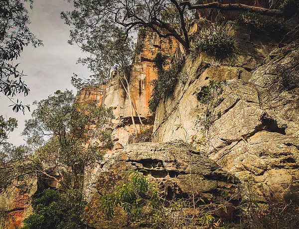
CARNARVON GORGE / CARNARVON NATIONAL PARK
Carnarvon Gorge At a Glance
Carnarvon Gorge sits right at the top of our Queensland national park rankings (if you don’t know, the husband and I love to rank national parks, hiking trails and campgrounds).

While Carnarvon Gorge is the only 2WD-accessible section of Carnarvon National Park, it is literally the cherry on top—a wide sandstone gorge with Carnarvon Creek running in the middle, ancient king ferns and fan palms, and evocative rock art. It’s one of Queensland’s most special places.
And best of all, it’s entirely accessible in a standard 2WD vehicle. While the final stretch of Carnarvon Gorge Road used to be gravel, it is now fully sealed all the way to the visitor centre.
You could visit on a day trip from Roma or Injune, but it’s much better to camp close by to make the most of your hiking adventure. Because camping inside the national park area is limited to school holidays, check out my complete Carnarvon Gorge camping guide to compare the private campgrounds that operate just outside the park boundaries year-round.
BLACKDOWN TABLELAND
Blackdown Tableland At a Glance
Located inland about 180km west of Rockhampton, Blackdown Tableland rises sharply on a high plateau. From up top, the park offers sprawling views into the plains below while also being a few degrees cooler than the surrounding country (definitely keep that in mind if you visit in winter).

It’s a compact national park but one that offers some unexpected beauty—from lush rainforest pockets and indigenous rock art to the beautiful Rainbow Falls and its tranquil rock pool. You’ll only need a day or two here but it’s a lovely oasis in a region dominated by commercial mining operations.
Access up the range is via a winding, narrow but sealed road that brings you up onto the plateau. It’s fine for standard cars but unsuitable for towing caravans or large camper trailers.
For campers, the Munall camping area is a further 8km past the main lookout along an unsealed road—drive with caution. You’ll also want to stick to the first camping area at Munall (there are two loops, the second one is 4WD-only).
The park’s 19km scenic Loop Road is off-limits to conventional vehicles as this 4WD-only track is quite rocky and rough in parts.
OUTBACK QUEENSLAND (RUGGED GORGES)
Most national parks in Outback Queensland are only suitable if you have a 4WD, that’s definitely true. However, there is one impressive spot inland that is entirely accessible on sealed roads.
PORCUPINE GORGE
Porcupine Gorge At a Glance
If you head about 400km inland from Townsville, just north of Hughenden, you’ll find a beautiful, rugged gorge that any conventional 2WD vehicle will handle with ease.

You can admire Porcupine Gorge from above at a couple of lookouts or head down the steep track into the gorge for an unmarked creekbed wander to see the famous Pyramid Rock up close.
The road from Hughenden is entirely sealed up right up to the day-use area. The only unsealed section is the short gravel loop around the camping area. If you want to stay the night, you’ll be camping in a bit of outback dust but it is a great spot to hang out for a couple of days and explore the gorge floor and enjoy the sprawling escarpment views.
TROPICAL NORTH QUEENSLAND (ANCIENT TROPICS)
This region is famous for its rugged 4WD adventures but it also hides one national park that offers a stunning glimpse into the ancient past.
DAINTREE NATIONAL PARK
Daintree At a Glance
Only a small part of Daintree National Park—or ‘the Daintree’ as it’s commonly known—is accessible to the public. There’s the pristine Mossman Gorge section, and once you cross the Daintree River via the cable ferry, you can drive all the way to Cape Tribulation in your 2WD to explore this section of the park.

While the walking tracks are mostly short boardwalks (plus a couple of challenging day hikes), the Daintree is really special because it’s one of the most ancient remnant rainforests on earth. There are plant species here that have existed for thousands of years. From rivers, creeks, waterfalls, beaches, lush rainforest and a scenic drive to Cape Tribulation, you can pick and choose what to explore.
Camping is restricted to commercial and private campgrounds, and Cape Tribulation is the literal end for conventional cars. Beyond this northern point, the Bloomfield Track begins and it’s high-clearance 4WD territory only.
ROAD TRIP DETOURS WORTH A STOP
CROWS NEST NATIONAL PARK
Crows Nest is located just north of Toowoomba along the New England Highway. If you’re bypassing the busy coastal strip and travelling north via the inland route, Crows Nest is a fully sealed detour that’s worth exploring for a day.

While it only has a small camping area and a couple of short walks, The Cascades tumbling down the granite creek are a lovely sight. If you’re passing through in the warmer months, you can hop into the rock pools for a quick cool down.
Planning a pitstop? Check out my complete guide to visiting Crows Nest National Park for track details, camping info and exactly how to find the cascades.
AUBURN RIVER NATIONAL PARK
Southwest of the tiny town of Mundubbera in the Wide Bay-Burnett region is tiny Auburn River National Park. It’s a neat little overnight spot if you’re on your way to the Sandstone Belt region.

The camping area is even smaller than at Crows Nest (a whole five sites) but the views from the escarpment into the rugged river gorge are fantastic. You can also take the short track into the gorge and scramble around the giant granite boulders.
The main access road (Auburn River Road) has a section of unsealed gravel at the end but it is generally well-maintained and perfectly fine for a standard 2WD and small caravans in dry weather.
Want to explore the gorge? Check out my detailed guide to Auburn River National Park to get all the details on the walking tracks and camping area before you go.
WRAPPING UP: TIME TO HIT THE ROAD
So that’s it—nine incredible national parks that you absolutely do not need a 4WD to explore. As I said above, there are plnety of other parks (like the Bunya Mountains or Cania Gorge) that are easily reached in a conventional car but these ones here are my top recommendations.
Did I miss your absolute favourite national park in Queensland? Let me know in the comments below. 🙂
Happy exploring,


No Comments